The shootdown of an Allied B-24 bomber on 21 November 1944
While the USAAF Chronology lists no 10th Air Force activities in Thailand for the period 20-22 November, on 21 November, one B-24 was shot down while making a bomb run on Kaeng Luang Bridge. The entire crew perished in the crash. A passenger, a British war correspondent, was also killed.
Relevant portion of page 1 of USAAF missing crew report (MCR) 10050 (click on image to enlarge):1Duff was buried with the crew at St Louis (Jefferson Barracks) National Cemetery, St Louis MO, USA on 22 Nov 1949.

The flight originated from Madhaiganj Army Air Base2 (Google Maps link), India; moving 850 km southeast to pass over Sagu Island3 (Google Maps link to present-day Saku Insel) off the Burma coast; then about 600 km almost due east to Sop Prap,4 about 12 km west of the town of Sop Prap and 50 km southwest of Lampang (Google Maps link), Thailand; with a further 70 km ENE to arrive finally over the bridge at Kaeng Luang (Google Maps link):5

Of the several descriptions in the MCR of the shootdown by other pilots in the raid, the following by 2LT John J Probst is the most informative:6
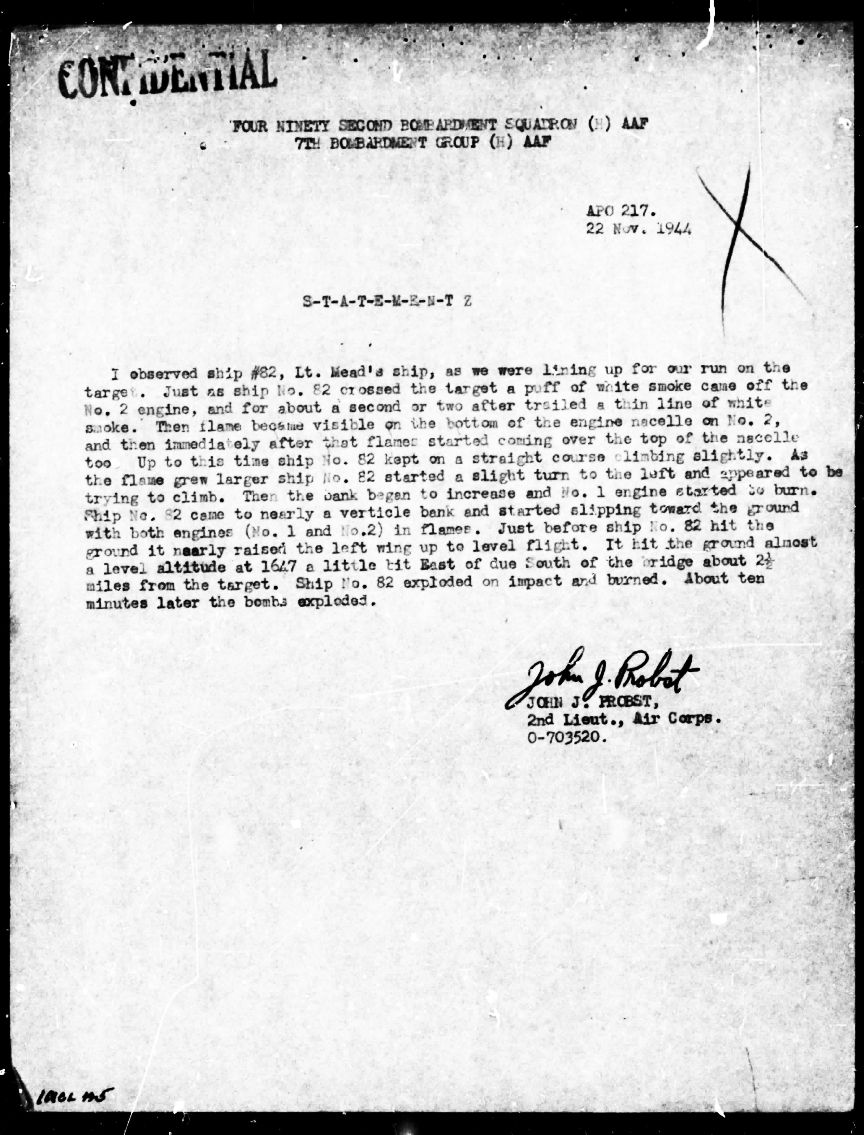
Transcript:
I observed ship #82, Lt Mead’s ship, as we were lining up for our run on the target. Just as ship No 82 crossed the target, a puff of white smoke came off the No 2 engine, and for about a second or two after, trailed a thin line of white smoke. Then flame became visible on the bottom of the engine nacelle too. Up to this time ship No 82 kept on a straight course climbing slightly. As the flame grew larger, ship No 82 started a slight turn to the left and appeared to be trying to climb. Then the bank began to increase and No 1 engine started to burn. Ship No 82 came to nearly a vertical bank and started slipping toward the ground with both engines (No 1 and No 2) in flames. Just before ship No 82 hit the ground, it nearly raised the left wing up to level flight. It hit the ground almost a level attitude at 1647 a little bit east of due south of the bridge, about 2-1/2 miles from the target. Ship No 82 exploded on impact and burned. About ten minutes later the bombs exploded.
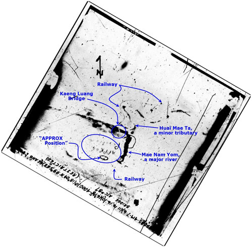
A very poor quality aerial photo (here annotated by author) locating the crash point was also included in the MCR:7
What should be added is that the low level approach that made the flight particularly vulnerable to ground fire was quite possibly due to applying a version of “skip bombing” as described in Dive, Glide, & Skip Bombing (offsite link).
However roughly the crash was located in this markup, it was sufficient to allow recovery of the bodies after the war, for all are now interred at Fort Jefferson Barracks National Cemetery in St Louis, USA.
Detail: at Mead’s recorded crash time, 1650 hrs, sunset was only an hour away: 1751 hrs.8

Thai Aviation’s Thai Air Accidents records (p 2):


As the only B-24 downed in the general area of Lampang, it would appear that the shootdown is described in this retrospective from the ground:9
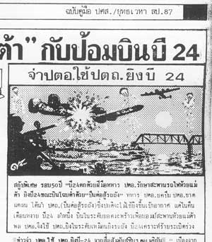
Translation of an accompanying story by a Sgt Tieb Chanphan:
I heard the remarkable story of a sergeant in an anti-aircraft battery who shot down a B-24 which was making a bombing run on Mae Ta Bridge. Because the battery had no anti-aircraft cannon in that time of severe shortages, the sergeant used an anti-tank gun on the four-engined plane when it appeared at low altitude one moonlit night. He hit the plane and it lost altitude, disappearing in the hills. Early the next morning, the sergeant found the plane wreck. He was able to get some souvenirs and then revealed the location of the downed plane and how he had shot it down with an anti-tank cannon.”10
21 November 1944
Allied reporting picked up the loss of 21 November:11

Transcript:
SOUTH BURMA AREA:
Bridges on the Bangkok-[Chiang Mai] rail line were attacked by 15 B-25s – results unobserved. 1 plane believed hit by machine gun fire crashed and burned. All crew killed.
07 December 194412

Appendix
Statement by Sgt Tieb Chanphan: translated from the Thai:13
FLYING FORTRESS B24 CONQUERED BY ANTI-TANK CANNON IN ‘MEATAR’
LAMPANG UNDER JAPAN OCCUPATION DURING WORLD WAR II
by SAK RATTANACHAI
DATE OF ARRIVAL IN LAMPANG: 22 OCT 1941
08 Oct 1941, The Greater East Asia War-16 Aug 1945 (Day of Peace)
Sergeant Tieb Chanphan: born 14 Feb 1917 (Valentine’s Day), owner of a writing material shop, “Phanphen”, located opposite Lampang Vocational College on Phahonyothin Rd (Thai Route 1), Arch of Victory Intersection, Lampang 52000, Tel: 217159
In Dec 1941, Japan came ashore from the Gulf of Thailand.
On 10-14 Dec 1941, Field Marshal Phibun signed orders.
On 22 Dec 1941, an anti-aircraft unit was relocated to Lampang.
“On 22 Dec 1941, the anti-aircraft battalion of the northwest arrived at Lampang train station. We marched to the city along a road where there was a sawmill. On the way to the city, we walked past a group of wealthy people, judging from their all riding bicycles. I was in charge of a medical unit under Lt Col Sawas Sawasronnapak as a commander in chief and Capt Praman Adireksarn as a division commander. We installed an anti-aircraft cannon beside the Lampang City Hall along the beltway road of the city. At that time the ruins of the old city wall, the arch of victory, and a canal still remained. We set up camp in a field at Boonyawat School and installed more anti-aircraft cannons and the tanks there.
“I was stationed at Lampang for one year; then I was switched to a sub-unit in Chiang Rai, Chiang Tung. I travelled there by military car, a Dodge. There we were lodged on Meu Hill where there were a racecourse, football field, and a beautiful pool. Our battalion put an observation post on the hilltop to watch for approaching aircraft. With the equipment used back then, we could only spot planes when they were already over our heads. My sole task was to report approaching aircraft to the commander via a field phone.
“Because I was head of a medical unit, I was sent many places, but eventually I returned to Lampang. There I heard the remarkable story of a sergeant in an anti-aircraft battery who shot down a B-24 which was making a bombing run on Meatar Bridge. Because the battery had no anti-aircraft cannon in that time of severe shortages, the sergeant used an anti-tank gun on the four-engined plane when it appeared at low altitude one moonlit night. He hit the plane and it lost altitude, disappearing in the hills. Early the next morning, the sergeant found the plane wreck. He was able to get some souvenirs and then revealed the location of the downed plane and how he had shot it down with an anti-tank cannon.”
Postscript
On 06 April 2022, a Thai newspaper, คม ชัด ลึก (offline link), announced the discovery of wreckage of what was believed to be a World War II Allied bomber, shot down while on a mission to bomb the railway bridge over the Huai Mae Ta in Long District of Phrae Province. . . .
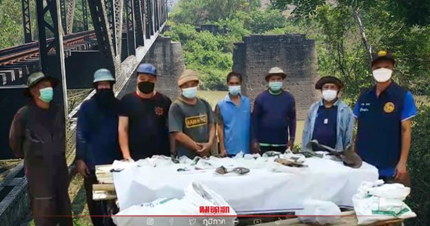
This per an announcement by Mr. Charoen Pukkaew, headman of Kaeng Luang Village, Village No. 5, Mae Pan Subdistrict, Long District that it had been found at the Community Forest Hall bomb pit area. . . .
However, the crash had actually been already documented in c1991 by Sak Ratanachai14; see retrospective from the ground and more extensive documented by the author in 2013-2014 from USAAF records (see above); but neither had located the crash site.
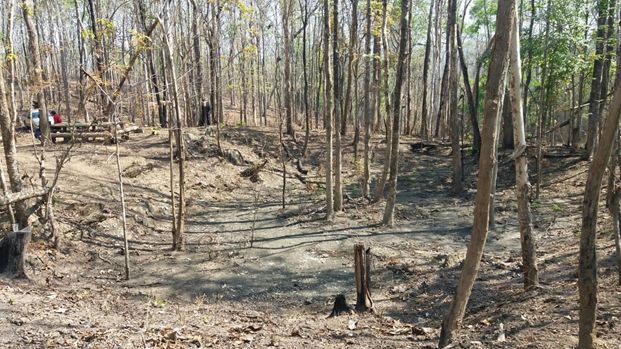
Jared Elison from the US Embassy in Bangkok was alerted to the newspaper’s discovery, visited the crash site and determined that it was already on record since an Allied recovery team had found it shortly after war’s end and retrieved crew remains (as noted above). He was able to advise of its exact coordinates (not well recorded in the days before GPS) on a hilltop south of the river, about 100 m from the original gravesites (Google Maps link).15 Some of the wreckage found was subsequently relocated to the nearby Wat Kaeng Luang (Google Maps link) compound. With the rather remote site now located, road access awaits funding.
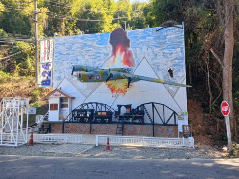
In early 2025, the author visited the general area and found a detailed sign (Google Maps link) along Thai Highway 11 publicizing the crash site. As viewed from Highway 11:
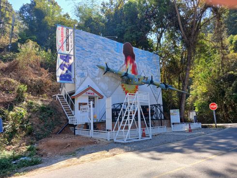
And as viewed from the side road:
A memorial service was held there on 24 January 2025.
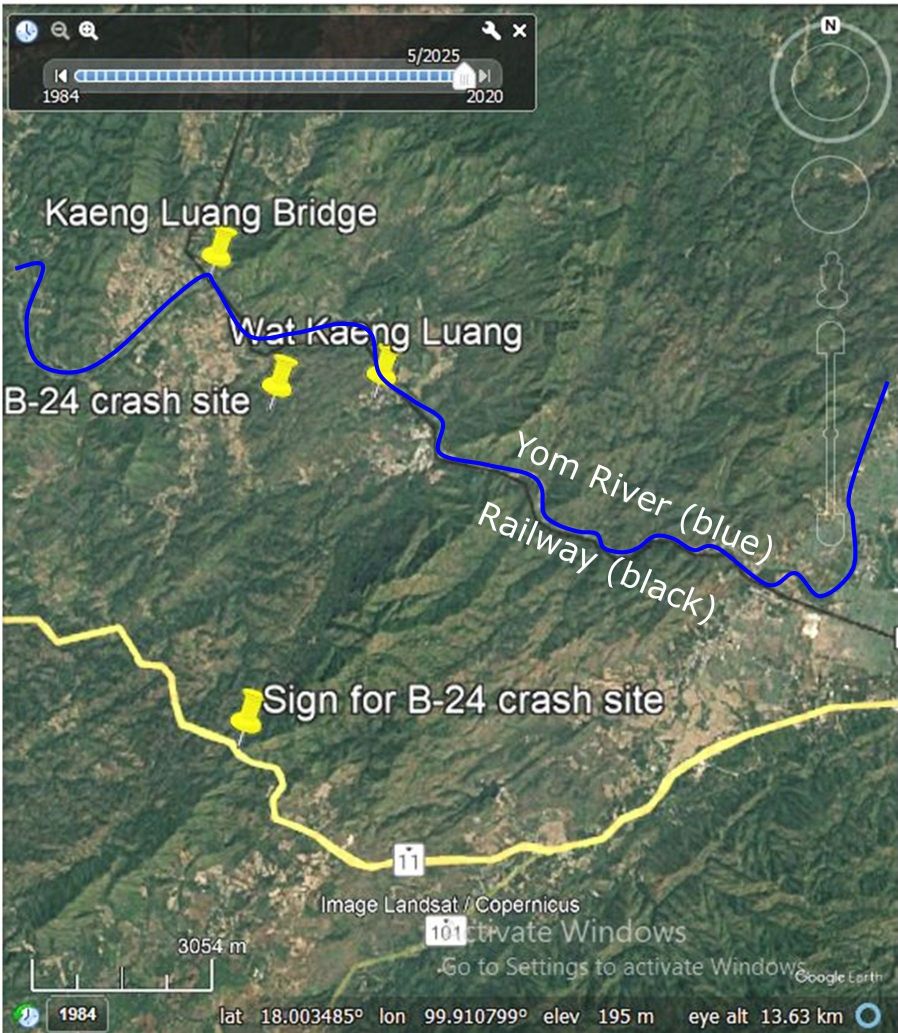
This map ties together all the points mentioned above16 (click to enlarge):
Oddity: a comparison of the Google Earth view of the bridge with the first newspaper photo shows that the latter was taken from the northerly end of the bridge looking south, whereas all the locations described were south of the bridge:
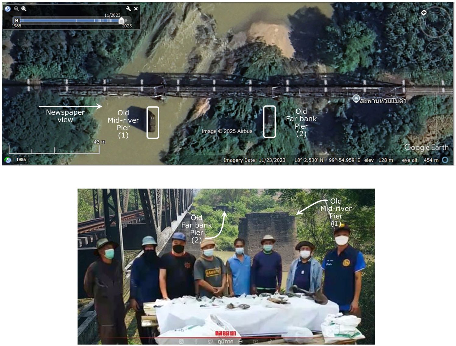
Mark Robinson (maintaining the YouTube Channel Series, State Railway of Thailand (offsite link) ) explains that the northerly side is easy to get to, while the southerly side involves a 3 km walk.17
Last Updated on 20 February 2026
- “Individual Report of Downed Aircraft”, Missing Air Crew Report” No. 10050, Report Date: 22 Nov 1944, p 2 (extract).
Source:
Accident-Report.com (offsite link)Miscellaneous links:
7th Bombardment Group (offsite link)
492nd Bombardment Squadron (offsite link)
A photo of the crew is no longer available on line at http://www.7thbg.org/MeadsCrew.htm: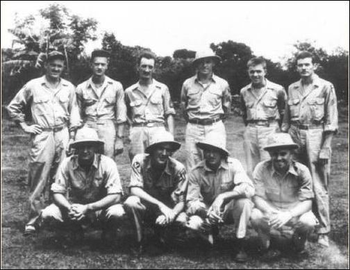
AG (Bill) Duff, British War Correspondent was ranked on the flight manifest as a “P/O”. Years later this led to confusion: see Help with rank in RAF (offsite link). The RAF has a rank of “Pilot Officer”, abbreviated “P/O”. However, neither the title nor the abbreviation were used in the USAAF and presumably here referenced “Press Officer” (Ranks/functions don’t seem to appear on British Forces Identification Cards; while below is an example from a different theater, it presumably is still typical (from War papers of Vivian Samuel, State Library, South Australia) (offsite link):

[↩]
- Two runways, 16/36 5300 ft and 5/23 3900 ft, in shape of “V” with vertex at N23°38.15 E87°20.79[↩]
- N18°48.4 E93°57.7, identified under “Course” in the MACR (p 1).[↩]
- “BANSABPRAP” in USAAF context probably refers to the peak of the prominent mountain ridge, Doi Chong (Google Maps link) (N17°53.43 E99°12.46) [↩]
- “Terrain” map from Nations Online Project: Searchable Map and Satellite View of Thailand using Google Earth Data (website no longer available). Annotations by author using Microsoft Publisher.[↩]
- Missing Air Crew Report” No. 10050, p 6.[↩]
- ibid, p 9. Original annotation (on margin) reads: (49285-4M-7-6) (11 16 16:10)(6 3/8″-4000)0(18°04N 99°56E) GEANG LUANG BRIDGE A/C #87 (RESTRICTED)
Image rotated, so that north points to top-of-page, and enhanced with IrfanView; annotated in blue using Microsoft Publisher, all by author.[↩]
- Per NOAA ESRL Sunrise/Sunset Calculator (offsite link). Table below is from Accident-Report.com. Geang Luang: N18°01 E99°57 per Geographical Names.[↩]
- รัตนชัย, สักดิ์, ปาะวัติศาสต์ศึกษายุทธเวหาลำปาง [Rattanachai, Saksern S, Japan in Lampang during World War II (Lampang: (self-published), undated)] Ch 70, p 114.
In an alternate account, Young, Edward M, in B-24 Liberator Units of the CBI (Oxford: Osprey Combat Aircraft-87, 2011), p 37, states that Japanese machine gunners brought down Mead’s plane.[↩]
- Translation of the entire interview with Sgt Tieb Chanphan as published is here. While the use of an anti-tank gun for anti-aircraft duty seems innovative, note that the IJA Model 98 20mm (p 217), the Model 96 Type 2 25mm (p 230), and the 40mm single and dual mounted (p 230) automatic cannons were all titled “antiaircraft antitank”, per Chapter 9, TM-E 30-480 Handbook on Japanese Military Forces (Washington: War Department, 1944). [Note added 05 Sep 2014][↩]
- India-Burma Air Force, Brief of Principal Air Operations (24 Nov 44), no page no, Item (2) of 21 Nov 44 (USAF Archive microfilm reel A8202 p0343).[↩]
- CBI-Roundup of 07 Dec 1944; reprinted from: New Delhi: New Statesman, 07 Dec 1944, no page no. Note that the article incorrectly interpreted Duff’s rank as “pilot officer” (see above for clarification). This would have been a reflection of the UK-orientation of the staff of the New Statesman.[↩]
- รัตนชัย, สักดิ์, ปาะวัติศาสต์ศึกษายุทธเวหาลำปาง [Rattanachai, Saksern S, Japan in Lampang during World War II (Lampang: (self-published), undated)] Ch 70, p 114. This appendix added 04 Jul 2014.[↩]
- Rattanachai, Saksern S, Japan in Lampang during World War II (Lampang: (self-published), undated), Ch 70, p 114.[↩]
- Jared Elison email of 13:16 11 Apr 2022[↩]
- image based on Google Earth view, annotated by author using Microsoft Publisher[↩]
- Mark Robinson email of 13:32 08 Sep 2018[↩]