1939: The Mae Hong Son1 Airstrip (Google Maps link)2 was included in airmail routes in Northwest Thailand starting in 1939:3

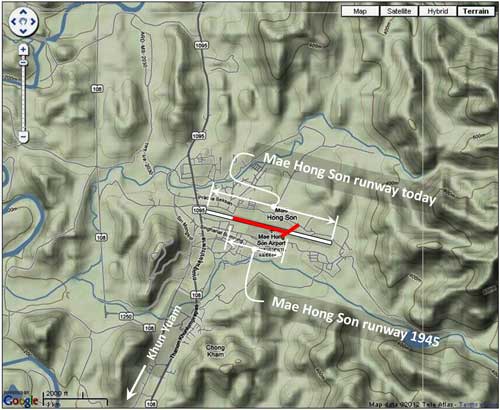
It is not now clear if the airfield’s original configuration included a crosswinds runway. An oblique photo of the field dated February 1942 shows at least part of the crosswinds runway (with perhaps the rest of it obscured by the poor quality of the image). Note the two runways appear below in red, superimposed on a current terrain map which shows the present-day single-runway airport in white.4 Compare with the 06 February 1945 view and note that the same obscuring of the far end of the crosswinds runway appears.
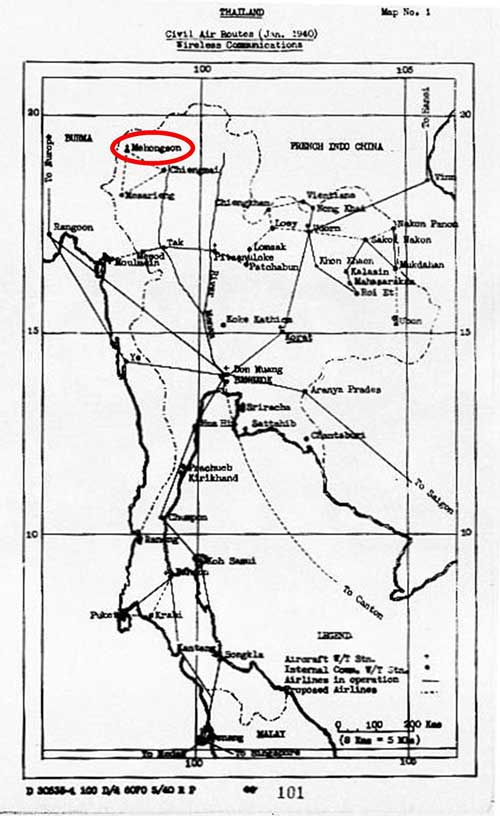
January 1940: The Aerial Transport Company of Thailand, Ltd, had been set up in 1930 to provide civil and commercial air services for Thailand; those services centered on air mail and passenger transport.5 The concept had prospered and, by early 1940, a map generated by the US War Department identified Mae Hong Son (Mehongson) as a proposed additional “airline” connection:6
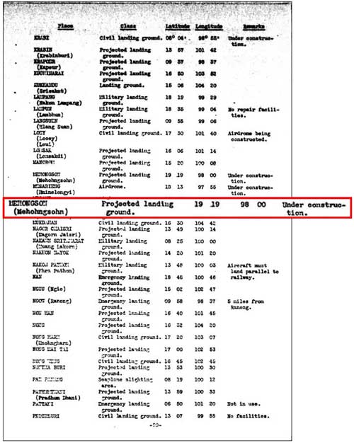
April 1940: While the US War Department continued listing Mae Hong Son under “additional airdromes, landing grounds, and seaplane facilities”, with status, “under construction”, it had already become operational in the previous year:7
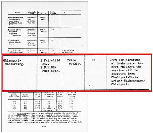
June 1940: By June 1940, the US War Department seemed to have accepted that Mae Hong Son airfield was operating:8
1941: Topological data for the Mae Hong Son area had been published in maps by the Royal Thai Survey Department (RTSD) in 1918. While rather coarse in detail, with terrain interval lines limited to 1000, 500, and 200 meters, they were the best available at the time, and the Imperial Japanese Army (IJA) relabeled them (and others in the series) in Japanese and issued the Japanese-language series, dating them 1940-1941.9 The IJA properly attributed the origin of the map:

Translation:
Remarks: From Thailand 1918, based on survey by the Thai Geographical Bureau; scale 1:200,000; one color printing
There were two consequences specific to Mae Hong Son:
- 1. The name, Muai To, had been used for Mae Hong Son district from 1917 to 1938.10 Hence, that name is displayed on the IJA map, with “Mae Hong Son” following in parentheses:11

Translation:
To clarify, while the district name differed during this period, the name of the province, of which it was a part, and the town, within the district, remained “Mae Hong Son”. The duality provides some unnecessary confusion in trying to sort out different accounts of the area.
- 2. Since the airstrip did not exist until 1939, it could not be shown on the IJA’s 1918 information-based map, and hence did not show on the IJA’s 1941 map12
June 1941: The Survey of India reissued revised maps of Burma, which included fringes of borderline Thailand. Though Mae Hong Son was titled as shown, unchanged from the original survey data from 1910-1912, it did include the alternative name, Muai Tau (Muai To):13
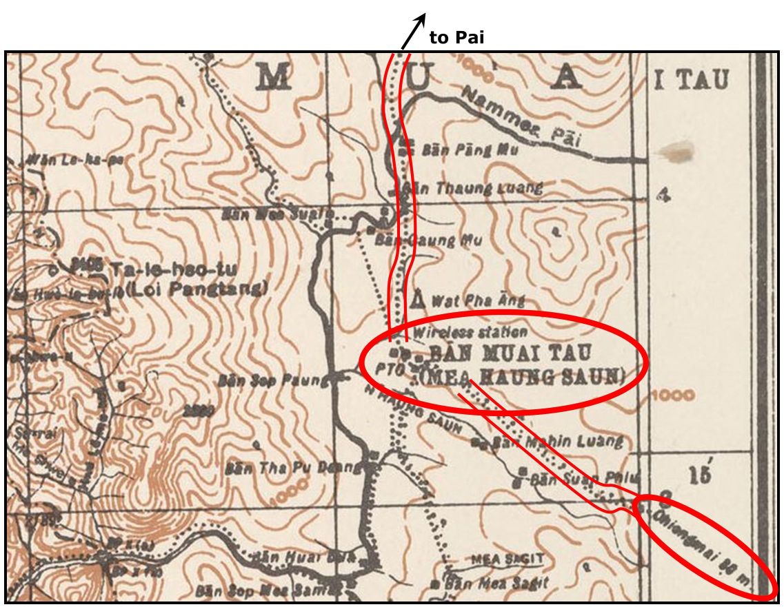
Some comments on this map:
- Similar to the IJA map, because of its earlier origin, it has no information on an air facility at Mae Hong Son.
- PTO: Post Telegraph Office.
- Wireless Station: this would appear to be in error: see footnote for wireless station.
- The connection southeast to Chiang Mai is composed of two symbols indicating a telegraph line and a path. This would be the telegraph line connecting Chiang Mai to Mae Hong Son, following the Old Elephant Trail. I’m not sure how accurate the routing shown is — it doesn’t conform very well to what Goodden described14
- The connection north (and east) to Pai shows only a path, but it actually followed a telegraph line to Pai.15
24 October 1941: Three American Volunteer Group (AVG) “Flying Tiger” P-40s (offsite link) based at Toungoo, Burma made a surveillance run on Chiang Mai. The flight may have been visible at Mae Hong Son.16
26-27 October 1941: IJAAF Ki-15s (offsite link) (“Babs”) based at Hanoi made high-altitude surveillance runs over Toungoo. Those flights might have been visible from Mae Hong Son.17
Next: Mae Hong Son Airstrip: 1942 to 1943
| First published on Internet | ||
| Many changes on p 0x which was then divided into pp 02 & 03 | ||
| pp 02 & 03 divided into pp 02-06; refs updated; Jagan opinion added. | ||
| p 05: added 17 Feb 1945 21PRS aerial photo flight report 17 February 1945 | ||
| Converted to WordPress by Ally Taylor | ||
| Updated, author errors & typos corrected | ||
- Mae Hong Son: also rendered Mehongson, Mehohngsohn, Mehongsawn, Me-hohngsohn, Mehonnggsohn (to add confusion, prior to 1938, the town was called Muai To (ม่อยต่อ) (Wikipedia: Mueang Mae Hong Son District (offsite link) ) [↩]
- N19°18.1 E97°58.3 Coordinates per Wikipedia) (offsite link) [↩]
- “Terrain” map from Nations Online Project: Searchable Map and Satellite View of Thailand using Google Earth Data; accessed 20 May 2012 (but link no longer functional). Annotations by author using Microsoft Publisher combine information from Young, Edward, Aerial Nationalism (Washington: Smithsonian Institute, 1995), p ix, and A Survey of Thailand (Siam), (Washington: US War Department, March 15, 1941) p 101, “Civil Air Routes (Jan 1940)”, (USAF Archive Reel B1750, p1823). The two routes with dotted lines are only from the latter source and are there commented as “proposed”, with Young explaining “The Transport Company continued expanding its air and bus routes during 1940. . . . an entirely new air route was being planned covering northwestern Thailand . . . from Chiang Mai to Mae Hong Song via Mae Sarang.” (pp 100-101). See January 1940 Civil Air Routes below.[↩]
- “Terrain map”, ibid. Overlay based on Airfield Report No. 32, Mar 1945, aerial photo “Mae Hong Son Landing Ground”, unnumbered page (USAF Archive microfilm reel A8056 p 53).[↩]
- Young, pp 76-102.[↩]
- A Survey of Thailand (Siam) (Washington: US War Department, 15 March 1941), Appendix III (untitled), Map No. 1 dated “Jan 1940”, p 101 (USAF Archive microfilm reel A2874 p1467) [USAF Archive microfilm reel B1750 p1823 duplicates]. Note that the US War Department version of Mae Hong Son’s introduction into the Thai Aviation Network does not coincide with that of Young. The latter, relying on company operational records, can be assumed to be the more accurate.[↩]
- ibid, Appendix I – Airdromes, Landing Grounds, and Seaplane facilities of Thailand, v. Additional Airdromes, Landing Grounds and Seaplane Facilities of Thailand, “correct up to April 1940”, p 89 (USAF Archive microfilm reel A2874 p1455).[↩]
- ibid, Section 45. Civil aviation, f. National air service (3) Operations (“on June 24, 1940”), p 28 (USAF Archive microfilm reel A2874 p1394). [↩]
- CSEAS Maps and Document Room Catalog: Thailand6-005 (offsite link) [↩]
- Wikipedia: Mueang Mae Hong Son District. (offsite link) [↩]
- My Ref: 02313 1095 213+ Mae Hong Son airport\Thai6005_003-N2E6 pta.jpg[↩]
- I mistakenly earlier stated that it had been added to that later edition: not so.[↩]
- from Trove Digital Library, Gordon Hannington Luce Map Collection, National Library of Australia, Item 61: Survey of India (1945). In Burma 1:253,440: Taunggyi (Sheet 93 H (International number: F-47T),)] (offsite link) [↩]
- Christian Goodden, Trek It Yourself (Halesworth: Jungle Books, 2000), p 401[↩]
- see communication[↩]
- Ford, Dan, Flying Tigers (Washington: Smithsonian Books, 2007), p 77.[↩]
- ibid[↩]