This page discusses a World War II aerial photo taken by the Royal Air Force (RAF) and provided on-line by the Geo-spatial Digital Archive Project (GDAP) in its Williams-Hunt Aerial Photograph Digital Collection. 1
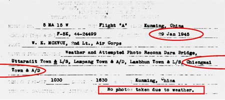
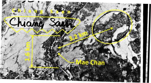
“Chiang Saen”2 is penciled-in on an aerial photo of Mae Chan 3 and a penciled-in circle implies the location of Chiang Saen:
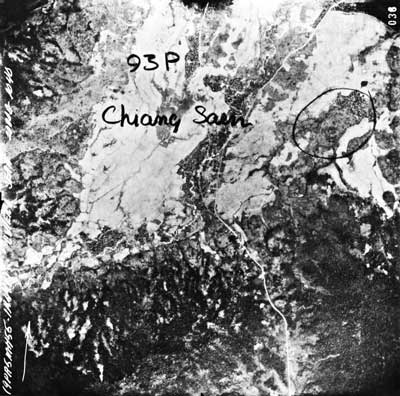
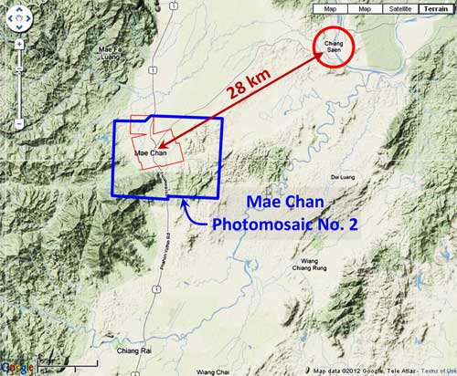
There is a problem, however — the photo does not ‘scale out’. The distance between Mae Chan which is clearly visible in the photo and the circle measure only about 3.2 km: 4
In actuality, the distance between the two towns is about 28 km: 5
In addition, there is a peculiarity about the two towns in that their shapes as viewed from the air are generally similar. In the photos below, the scale and true north are the same; hence, while similar, there are discernable differences between the two towns: 6
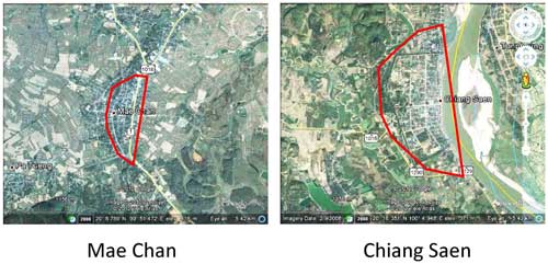
But primarily, the presence of the Mekong River to the right (east), which forms part of the old defense line for Chiang Saen, clearly differentiates the two; and it is this which strongly implies that the aerial photo is of Mae Chan and the penciled-in information is in error.
GDAP, the source of these photos, has asked that the following information be included regarding the aerial imagery shown above:
- Williams-Hunt Aerial Photos Collection
- Original from the School of Oriental and African Studies (SOAS), University of London
- Digital Data from Center for Southeast Asia Studies (CSEAS), Kyoto University
- Digital Archive from Chulachomklao Royal Military Academy (CRMA), Thailand
| First published on Internet | ||
Last Updated on 29 February 2024
-
The collection and its origin are described in detail in:
Lertlum, PhD, Col Surat, and Dr Elizabeth Moore, Williams-Hunt Aerial Photograph Collection, (undated); available as here linked.
Moore, Elizabeth, The Williams-Hunt Collection, Sari – International Journal of the Malay World and Civilisation, 27(2)(2009), pp 265-284.
Periasamy, Makeswary, “A View from the Top“, biblioasia, 5(1) (Apr 2009), pp 38-42.
[↩]
- N20°16.58 E100°05.22 Source: Google Earth fix on apparent center of town.[↩]
- 02509.jpg[↩]
- Extract from 02509.jpg. Annotations are by author using Microsoft Publisher.[↩]
- “Terrain” map from Nations Online Project: Searchable Map and Satellite View of Thailand using Google Earth Data. Annotation (red & blue colored items) placed with Microsoft Publisher by author.[↩]
- Both images from Google Earth, with annotations added by author using Microsoft Publisher.[↩]