This page discusses World War II aerial photos taken by the Royal Air Force (RAF) and provided on-line by the Geo-spatial Digital Archive Project (GDAP) (link1 no longer active) in its Williams-Hunt Aerial Photograph Digital Collection (link2 no longer active)
The Williams-Hunt collection has aerial photo coverage on two different dates for Chiang Rai:3 4
Photomosaic No. 1
The area around Chiang Rai outlined above in red was recorded on six RAF aerial photos dated 05 October 1944, plus two undated:5
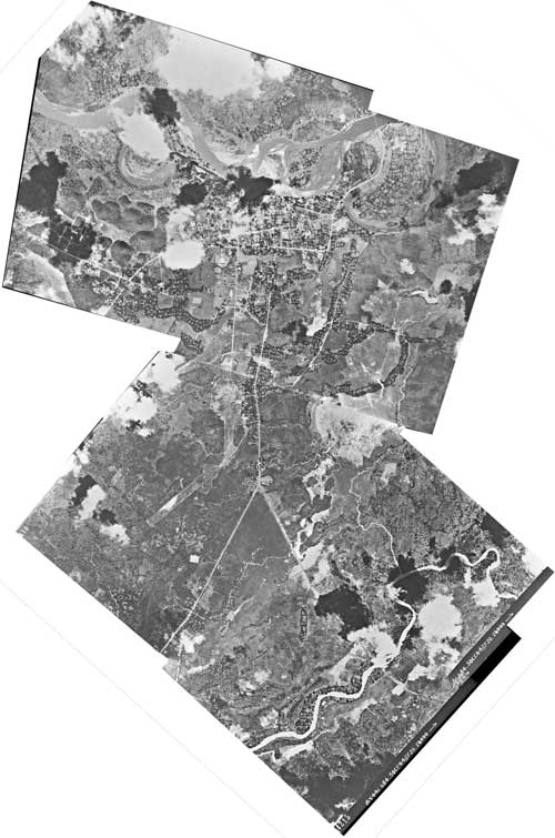
A higher resolution image is available for download here.6
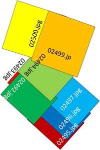
The following GDAP images were used in the above photomosaic:7
02492.zip
02493.zip
02494.zip
02495.zip
02496.zip
02497.zip
02499.zip
02500.zip
and assembled approximately like this, using a combination of ICE and manual fitting:8
Photomosaic No. 2
An alternate mosaic, as outlined in blue on the site map above, had been assembled earlier by Allied intelligence and published on 15 November 1943:9
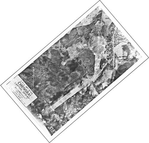
A higher resolution image is available for download here.10
GDAP, the source of these photos, has asked that the following information be included regarding the aerial imagery shown above:
- Williams-Hunt Aerial Photos Collection
- Original from the School of Oriental and African Studies (SOAS), University of London
- Digital Data from Center for Southeast Asia Studies (CSEAS), Kyoto University
- Digital Archive from Chulachomklao Royal Military Academy (CRMA), Thailand
| First published on Internet | ||
| Converted to WordPress by Ally Taylor | ||
| Updated, author errors & typos corrected | ||
Last Updated on 8 January 2026
- http://gdap.crma.ac.th/[↩]
- http://gdap.crma.ac.th/index.php?option=com_content&view=article&id=14&Itemid=3[↩]
- N19°54 E99°50 Source: Google Earth fix on apparent center of town.[↩]
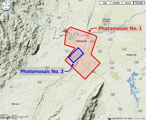
- “Terrain” map from Nations Online Project: Searchable Map and Satellite View of Thailand using Google Earth Data (link: http://www.nationsonline.org/oneworld/map/google_map_thailand.htm is no longer available). Annotation (red & blue colored items) placed with PhotoShop by author; my ref: \02370 Other locations\02370 Chiang Rai\NOL-CNR-Locatn-map-w-mosaic-outlines.jpg[↩]
- Photos were assembled using Microsoft’s ICE, a panorama program, as much as possible. Order of assembly was important: images 02492-0294 and 02495-02497 were assembled first and then joined. 02499 and 02500 were then also processed by ICE, but had to be manually added to the resulting composite because it did not sufficiently overlap the other photos for the ICE program to stitch them together.
Mosaic has been oriented so north is top-of-page.[↩]
- my ref: \02370 Other locations\02370 Chiang Rai\WH aerials\CNR micro 02492.jpg[↩]
- The files used here are 1024 KB and are no longer available from GDAP for download; my ref: bPROJECT\_MAPS\THAILAND Maps\Williams-Hunt (WH) Aerials\CNR\CNR Originals\CNR proper\[↩]
- Drawn by author with Microsoft Publisher; my ref: \02370 Other locations\02370 Chiang Rai\Chiang Rai 8 aerials fitted.jpg.[↩]
- Allied-generated photomosaic has been oriented so that north is top-of-page; my ref: \02370 Other locations\02370 Chiang Rai\WH aerials\a02491 CNR Sum ea-rotated.jpg[↩]
- my ref: \02370 Other locations\02370 Chiang Rai\WH aerial rev\Downloads fm website\CNR macro 02491.jpg The original link < http://gdap.crma.ac.th/whc/thailand/Chiang_Mai_Chiang_Rai/thumb1024/02491.jpg> for the GDAP image, 02491.jpg, which was the source for the above Allied-generated photomosaic, is no longer available on-line.[↩]