The map above 1 shows the approximate location of the current day runway 2 at Pai 3. No evidence has been found that air facilities existed at Pai during WWII.
An airstrip at Pai is mentioned in neither Royal Thai Air Force histories, 4 Nor by primary Japanese sources. 5
Allied intelligence surveilled the area and noted road building activity towards the end of the war, but never reported the presence of a runway.
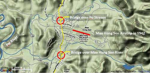
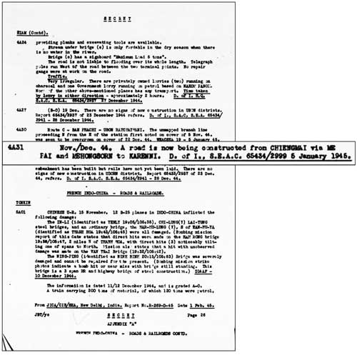
November-December 1944: Allied intelligence noted a road under construction from Chiang Mai via Pai and Mae Hong Son into Karenni in Burma: 6
Transcription:
Nov/Dec 44. A road is now being constructed from CHIENGMAI via ME PAI and MEHONNGSORN to KARRENNI.
D of I, SEAC 65434/2999 6 January 1945
Karenni, or Karenni State, in Burma is now Kayah State, adjacent to Mae Hong Son Province, Thailand. Actually Allied intelligence understated the objective of the roadwork, which was actually Toungoo, a major transport hub in the Bago Region, more than 100 air km west of Karenni.
March 1945: Allied intelligence further noted that Pai, under its alternate name, “Wieng Tai”, was part of a development of IJA routes between northwest Thailand and Burma. 7 No mention is made of an airstrip at Pai. The village at the other end of this stretch, Sobhuisai, does not appear on modern maps, but the coordinates cited, N19°32 E98°06, place it in the area of present-day Ban Mae Suya (Route 1095: Station 168).

Transcript:
WIENG TAI (LY220390) – SOB HWE SAI (SOBHUTSAI) (N19°32 E98°06)
At WIENG TAI a route, seen in air photographs taken from Beaufighters (08 November 1944), leads as far as SOB HWE SAI, runs north and then west until it joins the fair weather pack track between MEHONGSON (N19°19 E98°00) and the frontier. The part of the route observed was described as being a road in good condition but, due to severe gradients, unlikely to be suitable for [motor transport].
COMMENT: The 1:1,000,000 Scale map of SIAM shows a track, which runs in parts through very difficult terrain, from WIENG TAI to SOBHUISAI. The latter village is at the base of a high mountain range. It seems very unlikely that this track will be made use of as an escape route from BURMA, even for small bodies of men.
The village at the other end of this stretch, Sobhuisai, does not appear on modern maps, but the coordinates cited, N19°32 E98°06, place it in the area of present-day Ban Mae Suya (Route 1095: Station 168). Location of the section of road identified from aerial photos is shown in red over gray: 8

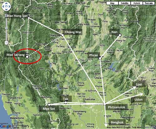
June 1945: Pai, again called “Wieng Tai”, is mentioned as part of an improbable route running southwest to Mae Sariang. 9 No mention is made of an air facility at Pai.

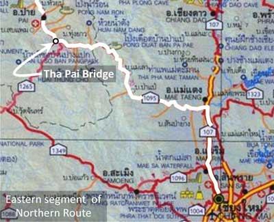
The eastern anchor point, “San Mahason”, assumed to be now Mahaphon, is in Amphur Mae Taeng, about five kilometers north of Mae Malai where the old road from Chiang Mai actually turned west towards Pai. The route, sketched in below as implied by its general description, suggests that whoever was “interrogated” was either not very familiar with the local geography or was intentionally trying to mislead his interrogators. 8

While roadways of varying quality do now exist through the central part of the route as traced, that route has never been improved as a whole.
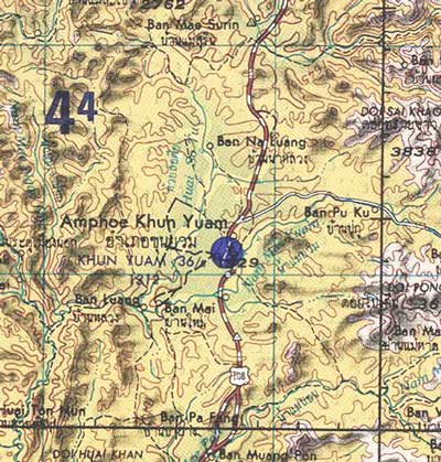
In any case, the point here is that Pai was seen as a key location in route planning, but an airport there was not deemed relevant throughout the war years (in contrast, see Khun Yuam Airstrip).
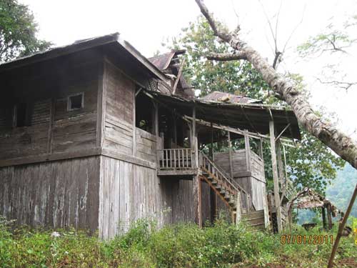
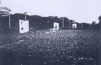
1947: Two years after the war was over, Field Marshall Phibun flew into Pai to land at an airstrip at Tambun Wiang Nuea built specifically for his visit. Construction included three “cabins” (illustrated below) for accommodation of Phibun and staff. 10 Thus is established the origin of the airstrip.
February 1971: An Air America listing of facilities in Thailand includes two airstrips at Pai. 11

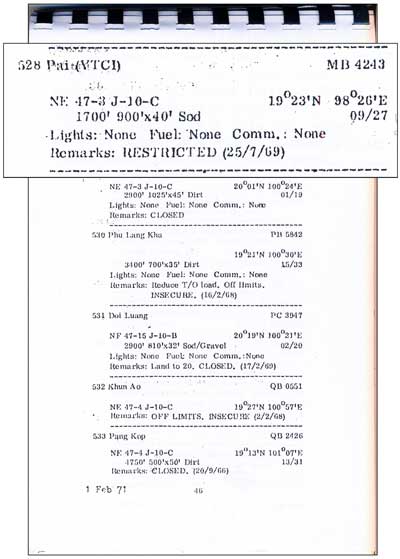
The Air America locations plot as: 12
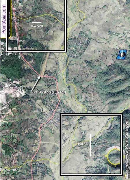
There is no evidence of either today. It is possible the listings were in error because the airstrip that was put in during 1947 and continues today as Pai Airport, was not included in this 1971 listing.
1994: A special report recorded this view, looking north, of the Pai airstrip: 13

And in the airstrip, the three cabins that had been built for Phibun’s visit in 1947: 14
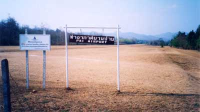
1999: A better view of the airstrip at a later date. 15 The sign in Thai reads:
Royal Thai Air Force Property, Keep Out
There is also a rumor that there is or was a small airstrip in the “Queen of the Battle” (Sona Pundit) army camp, though it is not apparent via Google Earth. 16
AIRPORT CURRENT STATS 17
Name: Pai Airport – VTCI
Coordinates: N19°22.2 E98°26
Runway Heading: 19/01
Length: 800 meters
Slope: 1° downslope to the north
Elevation: 1550′
Obstructions: 20′ trees on either end of airstrip (Nov 2003)
The runway was apparently first paved in 2006 or 2007 per Thai Flying Club photo captions; and by Feb 2011 featured an extension to the north.
| 0 | 2012 Aug 26 | First published on Internet |
| 1 | 2013 Apr 15 | Numerous errors corrected; two alternate route maps added |
| 2 | 2024 Feb 29 | Converted to WordPress by Ally Taylor |
| 3 | 2025 Mar 25 | Updated, author errors & typos corrected |
- The location map is taken from แผนที่ทางหลวงประเทสไทย Scale: 1:1,600,000 (กรุงเทพมหานคร:กรมทางหลวง, 2009) [Road Map of Thailand, Scale 1:1,600,000 (Bangkok: Department of Public Highways, 2009)], a folded map. Annotations are by author, using Microsoft Publisher. The northern route, shown in white, was mapped out by Tanaka in conjunction with an IJA colonel in August 1930 to facilitate the IJA’s anticipated invasion of India. It was roughly constructed by the IJA’s 15th Division, August 1943–July 1944 — completed far too late to support what turned out to be the IJA’s disastrous failure in Imphal / Kohima. However, it was used by some IJA forces retreating from that defeat passing primarily through Khun Yuam. The route is here assumed to approximate currently existing roads. [↩]
- N19°22.40 E98°26.17 Coordinates are per Google Earth[↩]
- Pai is the name of the amphoe (district). The village most closely associated with the runway is Wiang Nuea, or Wiengnua (เวียงเหนือ).[↩]
- บระวัติกองทัพอากาศไทย พ.ศ.๒๔๕๖ ๒๕๒๖ กองทัพอากาศ พุทธศักราช ๒๕๒๖, [Royal Thai Air Force Official History 1913-1983 (Bangkok: Royal Thai Air Force, 1983)] and ประว้ติกองท้พอากาสในสงครามมหาเอเชียบูรพาระหว่าง พ.ศ. -๒๔๘๔-๒๔๘๘ [History of the Royal Thai Air Force in the Great East Asia War between 1941-1945 (Nakhon Ratchasima: Somboon, 2021)]. Nor in ประวัติศาสตร์การสงครามของไทย ในสงครามมหาเอเชียขูรพา กรมยุทธศึกษาทหาร กองบัญชาการทหารสูงสุด พ.ศ.๒๕๔๐, [History of the Royal Thai Army during World War II](Bangkok: Royal Thai Army Command School, 1997).[↩]
- 戦史叢書 (東京: 防衛庁防衛研修所戦史室 (編集), —-年) [Senshi Sosho (Tokyo: Defense Agency, National Defense College Military History Room, various dates)].[↩]
- “Siam-Roads & Railroads”, Transportation Report: Road, Railroad, and Inland Waterways (China-Burma-India Joint Intelligence Collection Agency, 1-15 Jan 1945), p 26 (USAF Archive microfilm reel A8044 p 478) [↩]
- Communications in Siam, French Indo-China, & Yunnan, (?: Inter-service Topographic Department (SEAC), 01 Mar 1945), Part I: Siam, A: Roads, 5. Japanese Development of Routes between Burma and North West Siam, p 6 (USAF Archive microfilm reel A8021 p 164) [↩]
- Source for the map is as noted in note 2a above.[↩][↩]
- “Siam-General”, Transportation Report: Road, Railroad, and Inland Waterways (China-Burma-India Joint Intelligence Collection Agency, 1-15 Jul 1945), p 12 (USAF Archive microfilm reel A8044 p 760).[↩]
- รายงาน การ สําร จอขุดค้น – ตาม โครงการ คึกษาเชิงอนรักษ์แหล่ง ฝังศพทหารญี่บุน – สมัย สงครามโลกครั้งที่ 2 จังหวัดแม่ฮ่องสอน – หัางหุ้นส่วนจํากัดเฌอ กรีน – เสนอต่อ – จังหวัดแม่ฮ่องสอน – สำนักงานโบราณคดีและพิพิธภณฑสถาน แห่งชาติที่6 ใชียงเหม่ (1999) [Report on Archaeological Research for the Japanese Soldiers Burial Project World War II Era – Mae Hong Son Province (Chiang Mai: Green Tree, LLP, Ltd, submitted by / for Mae Hong Son Province Archaeology & National Museum Office 6, Chiang Mai, 1999)], p 99. Hereafter: Report on Archaeological Research.[↩]
- Air Facilities Data Thailand 432 (?: Air America?, 1971), pp 17, 46. See Key for interpreting page content.[↩]
- PointAsia, accessed 06 Nov 2008. Annotations by author using Microsoft Publisher. The airstrips are located per Air America data which is accurate only to the whole minute. The squares around the two airstrips define the range of possible locations of the centerpoints of those airstrips as a function of the limited accuracy of the data — that is, a half minute either side of the stated point. The dimensions of the ‘squares’ are 1 minute (latitude=1.15 mi or 1.84 km; longitude as a function of this latitude=1.08 mi or 1.74 km). They are rendered here as squares of 1.80 km. Source for dimensions is Table of Lat/Long equivalents in km and miles.[↩]
- Report on Archaeological Research, Fig 64, p 101. While the report is dated 1999, the digital photo of the cabins (next) appears to have been taken in 1994 (see next footnote).[↩]
- ibid, Fig 67, p 102. The photo appears to display a digital label “94”, indicating it was taken in 1994, whereas the report was issued in 1999.[↩]
- Photo courtesy of David Hardcastle, circa 1999, “looking north from public road end”.[↩]
- The source would prefer not to be identified. There is no feature suggesting remnants of an airstrip. Slopes up to 8% on the site are too great to be practical. Entrance to the camp is at N19°22.51 E98°25.70. The camp is only about one kilometer west of the current airstrip and it may simply have been identified with the camp at one time.[↩]
- Thai Flying Club: Pai Airport[↩]