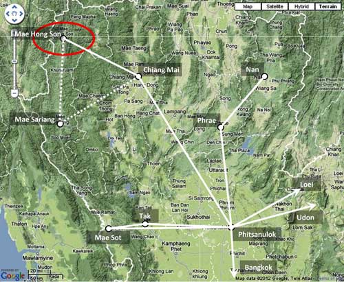
1939-1940: The Mae Sariang 1 Airstrip 2 was developed by Thailand’s Aerial Transport Company to expand its mail and passenger service in Northwest Thailand. 3
In Aerial Nationalism, Young mapped the Chiang Mai – Mae Hong Son route as functioning in 1939, 4 and commented that flights were planned for 1940 to go from Chiang Mai to Mae Hong Son via Mae Sariang; 5
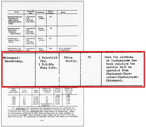
Confusingly, US intelligence reported the Mae Sariang airstrip functioning by June 1940, with the comment that service would be expanded to Mae Hong Son when facilities there were completed. 6
1941: In any case, airmail and passenger service in Northwest Thailand had expanded (and continued through the war years, ending only on 20 March 1945 with the downing near Khun Yuam of the single remaining aircraft providing service) 7

There is no mention of the airstrip being used by the Royal Thai Air Force in its official histories. 8 The official Japanese history of the war does not mention Mae Sariang, nor show it on associated maps. 9 The Journal on Collection of Japanese War Dead: Burma, India, Thailand reported that hundreds of IJA troops withdrawing from Burma died in the Mae Sariang area, but mentions the airstrip only in passing. 10
15 March 1941: Allied pre-war intelligence evaluation 11
January 1940 (data date): Thai Civil Air Routes 12

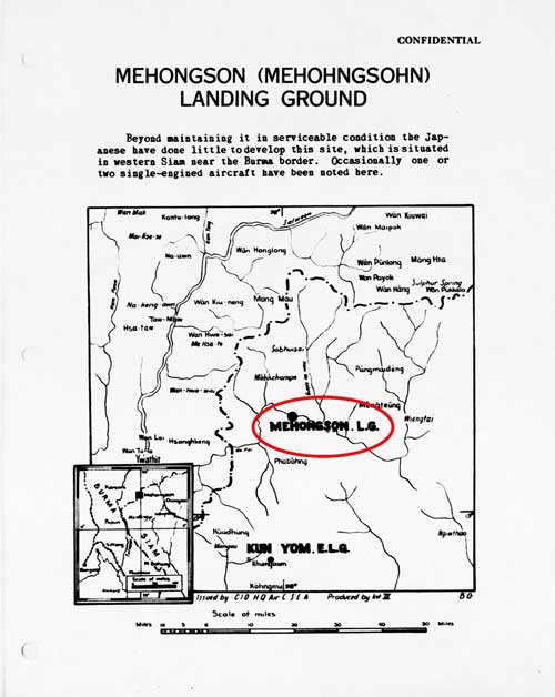
April 1940 (data date): Listed under additional airdromes, landing grounds, and seaplane facilities: 13
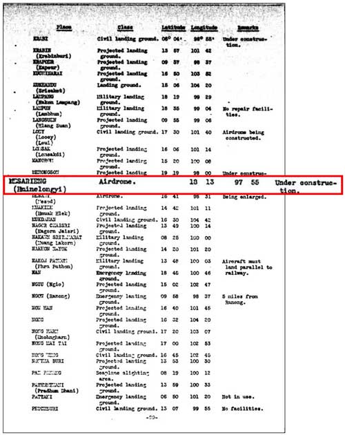
24 June 1940 (data date): Civil aviation, Operations 14
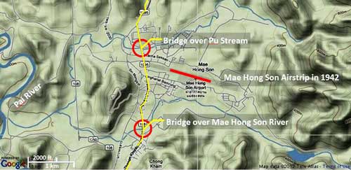
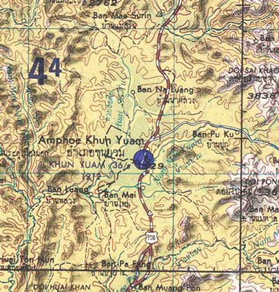
- Mae Sariang: also rendered Mesarieng, Hminelongyi (name was changed from Muang Yuam in 1917: that name being derived from the river flowing through the town [added 13 May 2015]).[↩]
- N18°10.90 E97°55.84 Per Google Earth[↩]
- Young, Edward, Aerial Nationalism (Washington: Smithsonian Institute, 1995), p 101[↩]
- Young, p ix.[↩]
- ibid, p 101.[↩]
- A Survey of Thailand (Siam) [hereafter, “Survey“] (Washington: War Department, 15 March 1941, Section 45. Civil aviation, [item] f. National air service (3) Operations, p 25 (USAF Archive microfilm reel A2874 p1455).[↩]
- “Terrain” map from Nations Online Project: Searchable Map and Satellite View of Thailand using Google Earth Data, accessed 20 May 2012, but no longer on-line. Annotations by author using Microsoft Publisher to combine information from Young, Edward, p ix, and A Survey of Thailand (Siam), p 101, “Civil Air Routes (Jan 1940)”, (USAF Archive Reel A2874, p1467). Solid white lines are per Young. Dotted lines are an additional route per US War Department: Young does not show Mae Sariang and connecting air routes.[↩]
- ประวัติกองทัพอากาศไทย ในสงครามมหาเอชียบูรพา พ.ศ. ๒๔๗๔ ๑๔๗๗ กองทัพอากาศ พ.ศ. ๒๕๒๕, History of the Royal Thai Air Force, 1941-1945 (Bangkok: Royal Thai Air Force, 1982) and บระวัติกองทัพอากาศไทย พ.ศ.๒๔๕๖ ๒๕๒๖ กองทัพอากาศ พุทธศักราช ๒๕๒๖, History of the Royal Thai Air Force, 1913-1983 (Bangkok: Royal Thai Air Force, 1983).[↩]
- 戦史叢書 (東京: 防衛庁防衛研修所戦史室 (編集), —-年) [Senshi Sosho (Tokyo: Defense Agency, National Defense College Military History Room, various dates)].[↩]
- 戦没者遺骨収集の記録 ピルマ・インド・タイ [Journal on Collection of Japanese War Dead: Burma, India, Thailand (Tokyo: All Burma Comrades Organization, 1980), hereafter, Journal], p 455.[↩]
- Survey, pp 1364 ff[↩]
- Survey, ibid, Appendix III (untitled), Map No. 1, p 101 (USAF Archive microfilm reel A2874 p 1467) [note that reel B1750 p 1823 duplicates this].[↩]
- Survey, ibid, [item] v. Additional Airdromes, Landing Grounds and Seaplane Facilities of Thailand, p 89 (USAF Archive microfilm reel A2874 p 1455).[↩]
- Survey, ibid, Section 45. Civil aviation, [item] f. National air service, (3) Operations (ibid, p 1394).[↩]