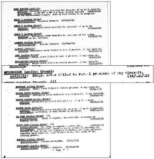
January 1944: “Miniatures” were a feature of Allied Airfield Reports for a time, designed to provide a quick reference for pilots to as many as 150 air facilities on one page. 1 This is a miniature for the Mae Hong Son airstrip. 2
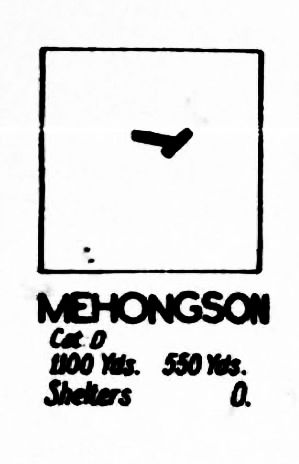
Cat [Category] D: Fair weather [use] only.
Runway lengths:
Long runway: 1100 Yds (yards, or 1006 meters)
Short runway: 550 Yds (yards or 503 meters)
[Aircraft] Shelters: 0 3
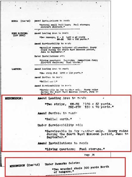
January 1944: An amendment to reporting was provided to supplement information about the Mae Hong Son airstrip.
There are two important points here:
- Improvements seemed to be continuing; though this may have been due to nothing more than a delay in publication due to priorities. But, if continuing, it is unclear whether work is by Thai or Japanese forces.
- Two wrecked sheds had been removed. The origins of the sheds is not clear, but it would be reasonable to assume that the wreckage was left over from the air raids in early 1942 — and was finally being cleared: 4
February 1944: No activity at the airstrip was reported, a reflection (finally?) of the 09 November 1943 IJA decision to abandon the Thai-Burma road connection — but also perhaps, again, only evidence of delays in processing data by Allied intelligence: 5

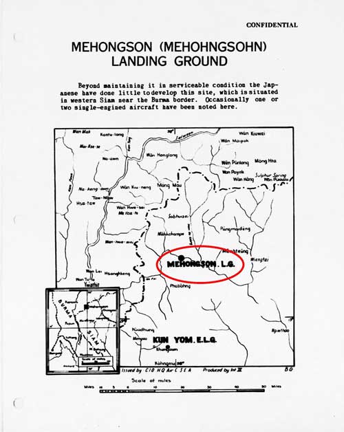
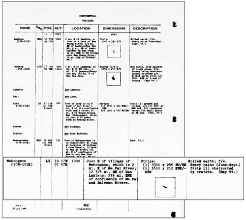
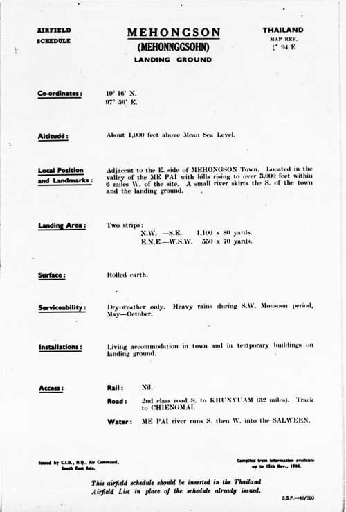
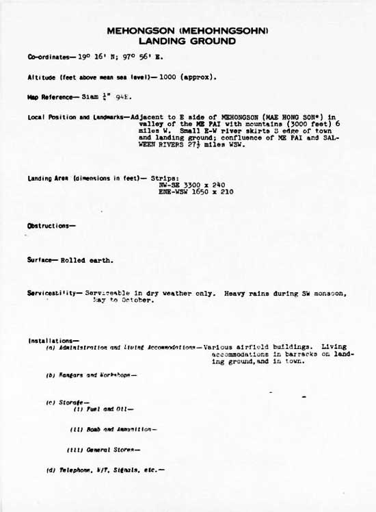
April 1944: A formal introduction, including a map, was provided for the Mae Hong Son airstrip in Spring 1944. 6 Aircraft reported as “occasionally” present were almost certainly Aerial Transport Company mail / passenger planes: 7
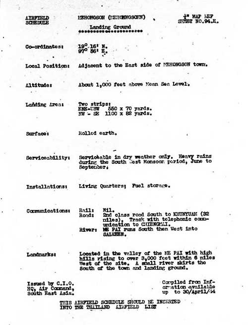
A formal “spec” sheet for the airstrip was included: 8
And a standard update on activities observed at the airstrip was included: 9
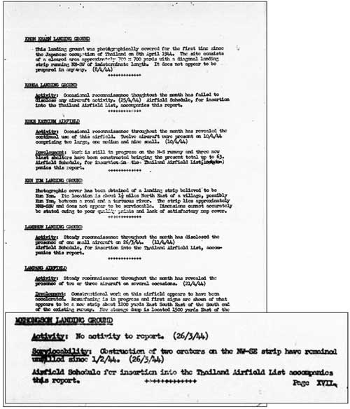
That the obstruction provided by two craters on the main runway had remained unfilled since 01 Feb 1944 suggests that the craters were the result of an Allied air attack after the last Airfield Report in January; however, there is no record of such. As well, the failure to repair the craters probably reflected changing priorities for the Thai Occupation Army as the IJA’s invasion of India matured.
Another section of that report in April 1944 made an observation significant for the entire history of the Mae Hong Son airstrip during WWII: 10
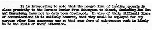
Transcription:
It is interesting to note that the meagre line of landing grounds in close proximity to the Burmese border from Mae Hong Son to Mae Sot, including Khun Yuam and Mae Sariang, have not to date been developed. In view of their difficult lines of communication it is unlikely however, that they would be employed for any purpose other than emergency use so that some form of maintenance work is likely to be the limit of their attention.
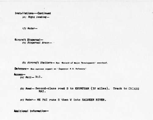
July 1944: A follow-up three months later provided details consistent with those previously presented: 11
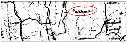
September 1944: Mae Hong Son was noted on a map of unknown vintage which was reissued to describe evasion / escape routes for downed pilots: 12
15 November 1944: An update generally duplicated details about the airstrip previously presented: 13
December 1944: And yet more update of the same material: 14
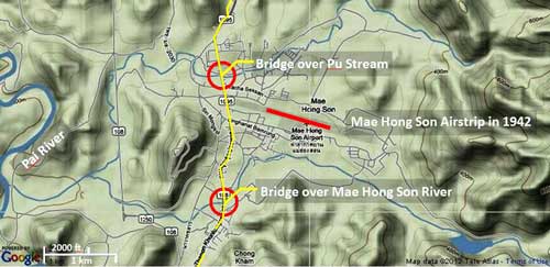
06 February 1945: Despite its poor quality, the aerial photo below is particularly useful in that it provides sufficient detail to fairly accurately locate the old airstrip with relation to the new. One error is that the north arrow should be pointing about 10° to the right: it appears to be aligned approximately with the north-south road to the west of the main runway — in actual fact, that road is on heading 170°-350°. See illustration in Introduction where the two runways below appear in red:
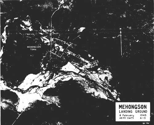
The quality of this photo is very poor because it is a microfilm copy of a printed publication of unknown quality.
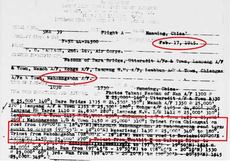
17 February 1945: The flight report below records the single aerial photo coverage of Mae Hong Son and environs by the 21st Photographic Reconnaissance Squadron (21PRS), part of the 14th Air Force headquartered in China. Other coverage obviously exists: 40PRS is credited with having taken the aerial photo above on 06 Feb 1945 per mission no. 5 M 75, but I have found no reports from that unit as yet. 15
15 March 1945: The Airfield Report comments probably demonstrate Japan’s growing inability to replace damaged / destroyed equipment: 16
Shores records:
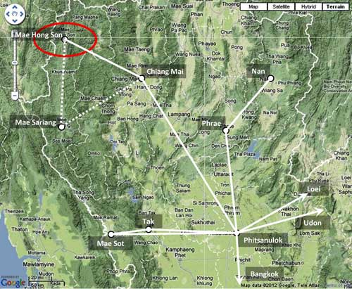
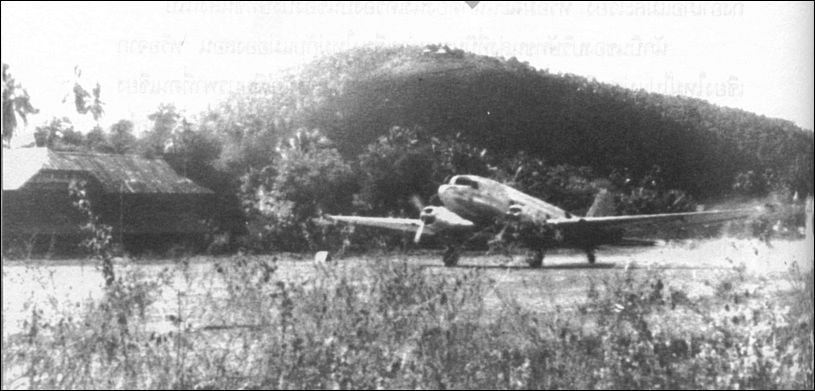
. . . fighter squadrons of the 2nd Air Commando Group flew to northern Thailand from Cox’s Bazar to strafe fields at Chiengmai and [Phrae], 17 which were being used by the Japanese as air staging posts. Near Chiengmai, Capt William C Marshall of the 1st Command Squadron [and flying a P-51] encountered a small single-engined aircraft which he identified as a ‘Stinson-type’ and shot it down. It was in fact a civilian Fairchild 24 of the Aerial Transport Company of Thailand 18 which was unfortunate enough to have arrived at exactly the same time as the US fighters. 19
Boonserm Satrabhaya records:
The pilot who flew the Norseman regularly from Chiang Mai to Mae Hong Son before the war, was a Mr Puai. Local people called the aircraft “Mr Puai’s aircraft”.
During the war, Mr Puai was shot down by an Allied aircraft while flying to Mae Sariang. The company and local people as well as his family were saddened to lose a good and friendly pilot. 20
Cherdchay Chomtawat records:
Interviewee No. 8, Mr Boon-ton Sriwichai:
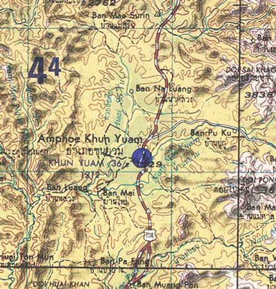
After [?] the war, there was a Thai mail plane (for letter delivery from Mae Hong Son to Amphoes Khun Yuam and Mae Sariang). This plane flew three times a month. One day this mail plane encountered British aircraft flying in the opposite direction. The British pilots saw the Thai pilot and mistook him for a Japanese. Later the mail plane encountered 40 – 50 British planes, two of which turned and attacked. The mail plane caught fire and crashed in the Ban Mae Surin area.
Villagers went to see the plane crash site and found four dead bodies. They included the pilot, Mr. Puai (surname unknown); a pilot assistant (name unknown); a Japanese soldier in uniform; and the superintendent of Mae Hong Son. The next day, the bodies were ceremonially cremated. The remains of the Japanese soldier were taken to Japan. There were some burnt banknotes (about 10,000 baht), two pistols, and other belongings in the crashed plane which district officers took. 21
Through 15 August 1945 (end of war): For record purposes, as of March 2025, good quality World War II era aerial photographs of the Mae Hong Song area have not been found.
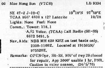
01 February 1971: Information in the Air America Air Facilities Data Thailand pamphlet 22 entry on Mae Hong Son airstrip does not mention the crosswinds runway, but is otherwise consistent with earlier observations. It would appear that the crosswinds runway had been abandoned. Other key items, location, runway headings, generally conform to past and present data on the airport. Use the Legend footnoted to interpret the AA entry for Mae Hong Son: 23
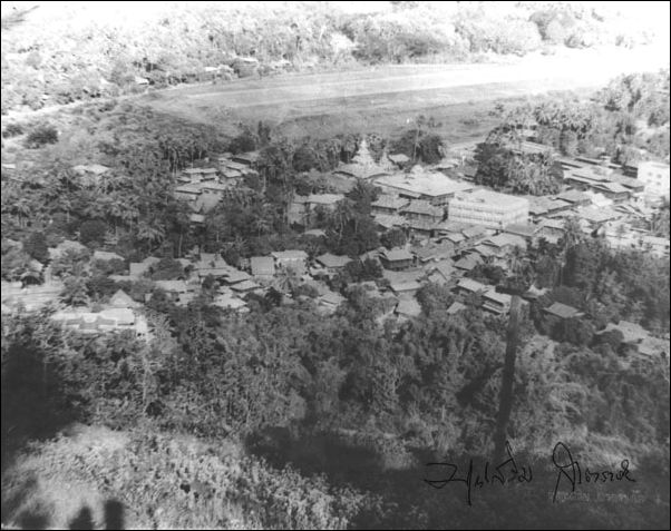
1974: From Chiang Mai University Library website “Lanna past through pictures”, is a view of the Mae Hong Son Airport runway in 1974. Taken by Boonserm Satrabhaya, he probably used a telephoto lens and shot from Wat Phra That Doi Keng Mu (N19°18 E97°57.6), looking northeasterly:
Another 1974 photo looks westward and shows the terminal building plus Doi Keng Mu in the background with the wat visible as two small white triangles near the summit: 24
1992 / 2007(?): The area is covered by Royal Thai Survey Department (RTSD) Map No. 4547 I, Title: Mae Hong Son:
7017 Series (Mar 1992): information is out-of-date
7018 Series (~2007): this is the current series and is controlled by copyright.
Distribution of this map is severely limited by the Thai government which seems to have a policy of minimizing the availability of government information about border areas. As such, the map is not available to the general public.
Nonetheless, coverage of the same areas in better quality and higher resolution / larger scale is paradoxically readily available in Google Earth, Bing, Flash Earth, Yandex, etc, directly on the Internet; plus Garmin, Magellan, Tom‑Tom, etc; and smart phone apps, whatever technology ‑‑‑ can be substituted.
AIRPORT CURRENT STATS 25
Name: Mae Hong Son Airport – VTCH
Coordinates: N18°18 E97°58
Runway Heading: 11/29 [106.26° / 286.26°]
Length: 2,000 meters (30 meters wide)
Slope: none
Elevation: 929′
Obstructions: Mountain on the far end of Runway 11. A one-way airstrip.
The Thai Flying Club webpage includes an excellent view on the approach path to the airport to illustrate why the airport is “one-way”.
- For example, see USAF Archive microfilm reel A8055 p 607[↩]
- Airfield Report No. 18, Jan 1944, “Airfield Miniatures”: Mae Hong Son, unnumbered page (USAF Archive microfilm reel A8055 p 422).[↩]
- “The number of aircraft shelters at each airfield is given as accurately as possible. Shelters wide enough to accommodate aircraft of 65/70 ft wingspan or more are classed as large; those under 65 ft as medium.” Airfield Report No. 14, Sep 1943, “Record of Airfield Activity and Development” [my source is currently unclear].[↩]
- ibid, Amendment to Airfield Report No. 18 [Jan 1944, Part II. “Amendments to Airfield Lists”, “Amendment No. 2”, undated, p 36 (USAF Archive microfilm reel A8055 p 475).[↩]
- Airfield Report No. 19, Feb 1944, “Record of Airfield Activity and Development”, p 24 (USAF Archive microfilm reel A8055 p 524).[↩]
- Siam (Thailand) List of Airfields and Seaplane Stations (Washington: Ass’t Chief of Air Staff, Intelligence, 1945), unnumbered page (USAF Archive Reel A1285, p 1233) [↩]
- Young, p 216.[↩]
- Airfield Report No. 21, Apr 1944, unnumbered page (USAF Archive microfilm reel A8055 p 670).[↩]
- ibid, “Record of Airfield Activity and Development”, p XVII, (USAF Archive microfilm reel A8055 p 713).[↩]
- ibid, p 4, “Review of Airfield Development in Thailand”, (USAF Archive microfilm reel A8055 p 618).[↩]
- Provisional Airfield List: Southeast Asia: Enemy Airfield Information Report No. 3, p 62 (USAF Archive microfilm reel A1284 p 1412).[↩]
- Extract from “Evasion Map of Burma 3 Sept 44”, ‘E’ Group Periodic Bulletin, Number 2, unnumbered page (USAF Archive microfilm reel A8021 p 0969) NB: date of original map is unstated. The dashed line which starts just to the west (left) of “Me’hohngsohn” (circled) is the recommended escape route from that area.[↩]
- Airfield Report No. 28, Nov 1944, unnumbered page (USAF Archive microfilm reel A8055 p 969).[↩]
- Siam (Thailand) List of Airfields and Seaplane Stations (Washington: Ass’t Chief of Air Staff, Intelligence, 1945), unnumbered pages (USAF Archive Reel A1285, p 1234).[↩]
- 21st Photographic Reconnaissance Squadron Report Mission No. 5 MA 39, 17 Feb 1944 (USAF Archive microfilm reel A0878 p0769).[↩]
- Airfield Report No. 32, Mar 1945, aerial photo “Mae Hong Son Landing Ground”, unnumbered page (USAF Archive microfilm reel A8056 p 126).[↩]
- Shore identified Phroe: that name does not appear on Thai maps. Similar in name in the area were Phrao, Phayao, and Phrae. Only the last had an air facility (N18°08 E100°10), 60 km ESE of Lampang and shown on US Army Series L509, NE 47-7 “Lampang”.[↩]
- “Stinson-type” aircraft: the Stinson SR-series was popular before the war per Wikipedia’s Stinson Reliant, but that reference does not list any models in Thailand.
Mentioned in a following version: The Noorduyn Norseman. “. . . it looked surprisingly like the Stinson SR 10.” per RCGroups.com‘s Noorduyn U-64 Norseman.
However, “Until 1940, the Noorduyn company had sold only 17 aircraft in total, primarily to commercial operators in Canada’s north and to the Royal Canadian Mounted Police.” per Wikipedia‘s Noorduyn Norseman.
On the other hand, Thai Aviation Net‘s Thai Civil Register and Royal Thai Air Force listings record no Norseman or Stinson models registered before the war; but the Royal Thai Air Force Register does record 14 Fairchild 24s exported to Thailand before the war (p 191) and its Air Accidents list records (p 4) a Thai Air Force Fairchild 24 shot down in Mar 1945 by a USAAF P-51.
It would appear that the aircraft could only have been a Fairchild 24 as Shores asserts.[↩]
- Shores, Christopher, Air War for Burma (London: Grub Street, 2005), pp 339, 342‑343.[↩]
- บุญเสิม สาตราภัย เชียงใหม่กับภัยทางอากาศ (กรุงเทพฯ: วิญฌูชน, 2003) Boonserm Satrabhaya, Chiang Mai and the Air War (Bangkok: Winyuchon, 2003), p 136. No date for the incident was provided.[↩]
- เชิดชาย ชมธวัช, บ้อมูลเส้นทางเดินทัพทหารญี่ปุ่น ในอำเภอบุนยวม สงครามมหาเอเชียบูรพา (สงครามโลกครั้งที2) จดทำโดย พันตำรวจโท [Chomtawat, Cherdchay, Information about Japanese soldiers traveling through Amphur Khun Yuam in World War 2 [15 Interviews] (self published, undated, but before 2004), unnumbered page.
Another source recalls three more deaths:
. . . there was a [Thai] mail plane (for letter delivery from Mae Hong Son to Amphoes Khun Yuam and Mae Sariang). This plane flew three times a month. One day, the mail plane met an [Allied Forces] plane flying in the opposite direction. The pilot wrongly identified the Thai pilot of the mail plane as Japanese and shot the mail plane which caught fire and crashed in the Ban Mae Surin area.
Villagers went to the crash site and found four dead bodies: the pilot, Mr Puai [surname unknown]; a pilot assistant [name unknown]; a Japanese soldier in uniform; and the superintendent of Mae Hong Son. ((Information about Japanese Soldiers, ibid.[↩]
- Air Facilities Data Thailand 432 (?: Air America?, Feb 1971), p 6[↩]
- ibid, p 6.
 [↩]
[↩] - Boonserm Satrabhaya, ibid, p 138. Both photos included here per his suggestion.[↩]
- Thai Flying Club webpage for Mae Hong Son.[↩]