1974-1983 (approx): Ban Pa Sed Airstrip1
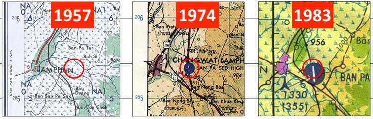
Reportedly destroyed near the end of the war by Allied bombing, the old Lamphun airstrip does not appear in the 1957 US Army map above.
Sometime between 1957 and 1974, a new four-lane divided highway linking Lampang and Chiang Mai, and eventually designated Thai Route 11, was constructed. Quite coincidentally, it was routed across the south portion of the old WWII Lamphun runway. The design for the road included a “highway strip”:
. . . a section of a highway or motorway that is specially built to allow landing of (mostly) military aircraft and to serve as a military airbase. These were built to allow military aircraft to operate even if their airbases, the most vulnerable targets in any war, are destroyed.2
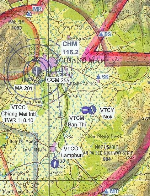
It was probably considered a reasonable and necessary precaution in Thailand since the kingdom bordered the former French Indo-China during the US’s relatively uncontained Vietnam War. And again purely by chance, the section designated as a highway strip, appears to have coincided, or nearly so, with the old WWII Lamphun runway; but it seems not to have been related to the runway which existed there during WWII. It was named “Ban Pa Sed Highway Strip”.
The February 1971 Air America listing of air facilities in Thailand does not list a Ban Pa Sed, nor does it list anything close to that location.3
However, the 1974 US Defense Mapping Agency map of the area shows both the new road north and an airstrip titled, “BAN PA SED HIGHWAY STRIP”. However, no “Ban Pa Sed” (Pa Sed Village) has been found (but local place names on the TPC are known to be notably flawed).
However, the 1983 Tactical Pilot Chart (TPC) for the area shows the airstrip, but with a status on the airstrip: “NOT USABLE”. This last was again probably primarily a result of the ending of the Vietnam War in 1975. There are no NOTAMS currently on-line for Ban Pa Sed:4
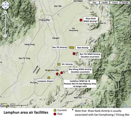
CURRENT AIR FACILITIES: Apparently the relatively flat river valley in which Lamphun lies makes it attractive for establishing airstrips. For “record purposes”, since the area seemed / seems so active in that respect, the following summarizes that activity.
Several air facilities are presently located in the area. None of them existed during World War II. None are shown on the Tactical Pilot Chart (TPC) covering this area. Hebels 5 provided this 2007 update for the Lamphun area:6
An ultra-light facility, M J, has since been established just northeast of Lamphun town.
Summary of past and current air facilities in the Lamphun area7
| (progressing from north to south)8 | ||
| N18°47.25 E99°08.86 | ||
| N18°40.6 E099°06.1 | ||
| N18°40.5 E099°06.6 | ||
| ? | ||
| N18°36 E99°03 | ||
| N18°34 E99°03 (estimated) | ||
| N18°34.5 E099°04 (estimated) | ||
| N18°34.06 E99°02.48 (estimated) | ||
| N18°33 E099°01 | ||
- Extracts from maps:
“1957”: “Lampang“, Map NE 47-7 Series L509, Edition 1-AMS, Army Map Service, Corps of Engineers, 8-58, 779707, compiled 1957.
“1974”: “Changwat Lampang, Thailand“, Series 1501, Sheet NE 47-7, Edition 2, Defense Mapping Agency, Washington, compiled August 1974.
“1983”: Tactical Pilot Chart, TPC J-10C, “Burma, Laos, Thailand”, Edition 4 (St Louis MO: Defense Mapping Agency Aerospace Center, 1983).[↩]
- Wikipedia: “Highway Strip“[↩]
- Air Facilities Data Thailand 432 (?: Air America?, 1971); but note that the pamphlet does appear to list “highway strips” (eg, 211 Kabin Buri (p 25) and 425 Kalasin (p 39). [↩]
- Tactical Pilot Chart (TPC) J-10C, Defense Mapping Agency Aerospace Center, 1983[↩]
- Hebels (external link[↩]
- Ban Thi (Lanna).[↩]
- Map is a composite of information presented above superimposed on a “Terrain” map from Nations Online, no longer available on-line. Annotations by author using Microsoft Publisher.[↩]
- As applicable, information is from the Thai Flying Club (external link).[↩]
- Ban Thi (external link) [↩]
- Nok (external link) [↩]
- M J (external link) [↩]
- Lampoon (external link) [↩]