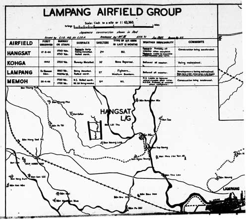
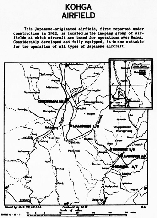
Postwar information
The very poor quality photo of the Mae Mo Landing Ground below was published in a Chiang Mai Museum report in 1999. The actual date of the photo is not known: 1
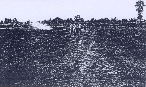
The caption (translated) reads:
Fig 10. Airport built by Japanese soldiers during WWII. It is now located in the Mae Mo Forestry Plantation, Ban Ta Sri, Tambon Ban Dong, Amphoe Mae Mo, Lampang Province. Before it was finished, it was attacked.
Though that description was known to us in early 2008 and was more specifically defined in early 2010 2 , a thorough inspection of Google Earth’s rendering of that area had found nothing suggesting an airstrip. We came to that conclusion with the experience of having visited the airstrip at Khun Yuam which, though not used since 1946, has survived very nicely. That conclusion turned out to be in error.
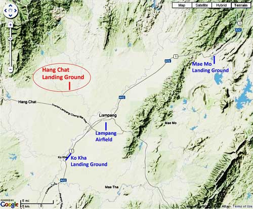
No further progress was possible until we discovered offerings of the US Air Force Historical Research Agency (AFHRA) in mid-2011. After ferreting out the information relevant to Mae Mo in webpages 1 and 2, and with numerous delays, we eventually found ourselves driving around the area indicated in the maps and diagrams on page 2 on 25 July 2013.
 We were heading SSE on a no-name road looking for any evidence of the old Mae Mo NE-SW runway and stopped at a point we thought it might have crossed the road, almost 70 years ago. Aside of the road where we stopped there happened to be a shop with a friendly shopkeeper. When asked if he knew anything about an old airstrip in the area, he, Sawai Maneesarn 3, immediately responded, yes: his shop was located right on the old runway, and that a mere 20 years ago, there was still visible evidence of the airstrip.
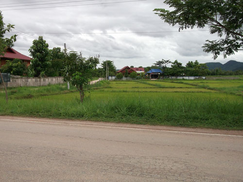
Looking out from his shop and across the road in a southwesterly direction, down what would have been the runway center line, we saw open fields bounded by a tree-lined, gravel road (to the left in the photo below): Photo 1 4
Traveling down that side road, we turned right into a single lane gravel road, stopped, and looked back at the shop (the blue roof in the distance). This is the view looking generally northeasterly from what would have been roughly midfield: Photo 2 5

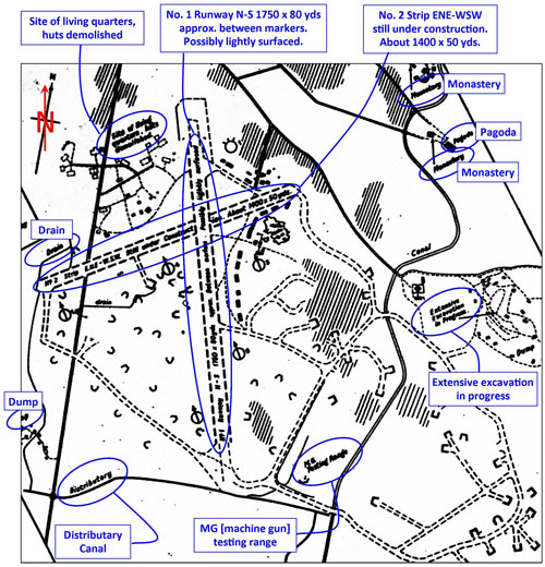
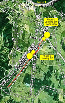
The two photos above were taken at the points shown on this enlargement of a small portion of the overlay map on the previous page: 6
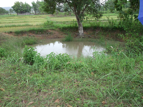
On that smaller road, we stopped and walked along paddy field dikes to look at various holes, which the shopkeeper thought might be vestiges of bunkers. Most of them turned out to be purpose-built unlined water reservoirs. However, two were decidedly different. Circular in shape, each looked similar to an old bomb crater we had seen in Chiang Mai on the old Sang Thai Rice Mill property. Diameters of the two here differ: 8 m and 13 m (approximate). The shopkeeper had mentioned that he thought the airfield had been bombed. Here is one of the two holes which appear to be bomb craters: 7
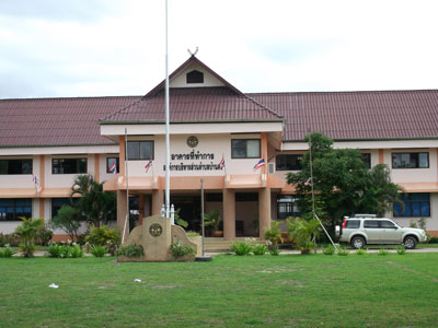
The shopkeeper also mentioned that there were possibly remains of a bunker near the local government building just up the street, at the intersection with Thai Route 1. So we ventured back over there where we found a standard Thai government building, in this case the administrative office for Tambon Ban Dong. It is located where the overlay on page 2 shows “Huts” near the top of the diagram: 8
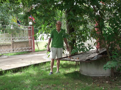
The area around the building’s westerly (exit) gate is of particular interest. A well just east of the gate is said to have been used by Japanese troops stationed at the airstrip. The vertical concrete pipe is the top of the well housing. Here an old metal sign has been recruited to cover most of the wellhead: 9
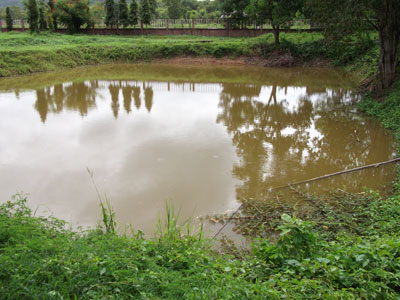
To the west of the same gate is a dug pond which now obscures the site where an unexploded Allied bomb rested for several years. The owner of land adjacent advised that the area had been roped off with warning signs until authorities removed the bomb: 10
That same landowner indicated that years ago he had filled in a bunker on his property as a part of preparing to farm the land. He recalled that he had been troubled for years with nightmares about Japanese soldiers crying out in despair; and that stopped when he filled in the bunker. 11
It is curious that the Mae Mo airstrip had been bombed. The airstrip was hardly of any significance: the reports on the previous pages indicate no aircraft were ever sighted there. The bombing might have been by Allied pilots whose only orders were bomb “targets of opportunity”; or it might also have been the result of pilots purposefully dumping their unused bombs before returning to base. There was a remark in a 19 June 1944 mission report, B-247, that a 22nd Bombardment Squadron, having failed to sight its target (the Kaeng Luang bridge), had “spotted an airfield having two runways crossing in an ‘X’ pattern” and dropped all its bombs on this alternate target. The Mae Mo facility is the only one in the northern Thailand area with runways in an “X” pattern.
For reference purposes, a profile of the main airstrip: 12
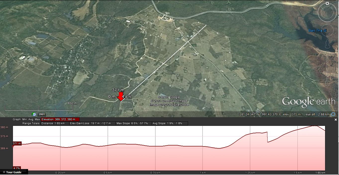
The abrupt elevation change towards the right (NE end) may be the result of a seam between two aerial images stitched together by Google Earth to form a mosaic.
To Do List
| p | Item |
| 1 | Thai Rte 1 sta at xsectn to road to a/f. Names of sois. |
| 2 | Take photos as shown in this markup: 13 |
| 3 | Re-GPS 2 shell hole locatns; photo 2nd hole |
| 4 | Property owner next to Tambon Ban Dong admin building:
a. Name, contact info: Mr Suk |
| 5 | Reforestatn Off at Mae Mo Forestry Plantatn, Ban Ta Sri:
a. Confirm name |
| 6 | Mae Chang Bridge:
a. |
Mae Chang Bridge (Railway Stationing: 599+848.50) 14 15
(aka “Mae Mo Bridge”)
(N18°16.480 E99°47.435) 16
The Mae Chang bridge was referred to as “Mae Mo bridge” by Allied Intel throughout the war. The Allies tied it to the general Mae Mo area, while those on the ground tied it to the waterway which it spanned, the Nam Mae Chang, and / or the railway station, a half kilometer southwest, Mae Chang, which in turn took its name from Ban Mae Chang, a small settlement about one kilometer NNE of the bridge. To complicate matters, Allied Intel was obviously aware that there was a significant bridge in the general area, but was notably vague about its location. The estimated location was actually moved around in intel reports and aerial photo requests as the war progressed, and did not appear to have been tied down until a month after it had been bombed as an alternate target.
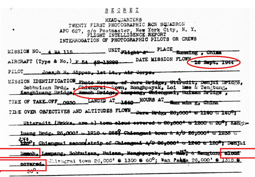
18 September 1944
The aerial photo order below mentions one photo objective as “Memoh Bridge”, though which bridge was intended in the order is unclear, for there are 21 small bridges along the railway all of which are 16-18 km (10-11 mi) south of the Mae Mo airstrips. 17 18
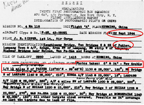
22 September 1944
Four days later there was a photo order that included two bridges south and southeast of Pakhem. 19 The coordinates for Pakhem are provided in the order and place it 12 km (8 mi) southeast of the Mae Mo air facility. No photo information for the targeted bridges is described in the results. 20
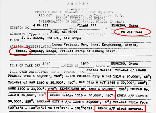
25 October 1944
An attempt to photograph Memoh A/F was unsuccessful due to cloud cover; but photos were taken of the Memoh Bridge on that date: 21
On this same date, the up-to-this-point anonymous [Mae Mo] Bridge seemed suddenly much better defined: 22
Transcription of applicable text:
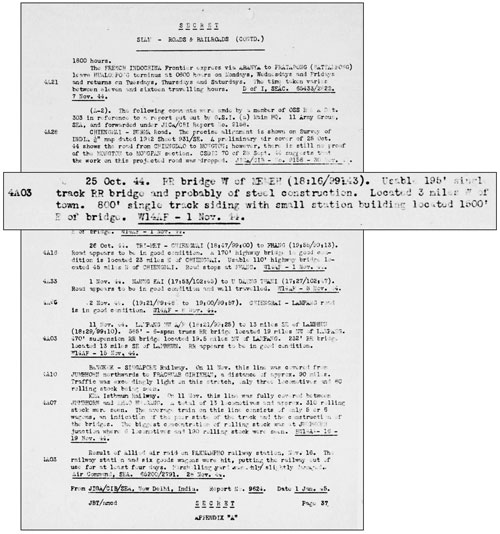
25 Oct 44. RR bridge W of [Mae Mo] (18:16/99:43) Usable 195′ single track RR bridge and probably of steel construction. Located 3 miles W of town. 800′ single track siding with small station building located 1500′ E of bridge.
Taking into account the different reference datum used during WWII, the broad coordinates given, N18°16 E99°43, could encompass Mae Mo station; however, there was no bridge of near that length within 3 mi west (or east) of the station. Thus, the additional information did not fit details on the ground; and the bridge remained “lost”.
25 November 1944
There is no mention in the USAAF Chrono of the Allies ever bombing the Mae Mo (Mae Chang) bridge by name; however 341st BG unit records did specifically mention bombing a bridge at approximately its coordinates as an alternate target when a planned attack on the Kaeng Luang bridge was apparently aborted, as noted in a mission report: 23
Seven 491st B-25s led by 1Lt. Fox departed Yangkai at 0400 hours and flew direct to attack the Kenghluang Rail and Road Bridge, IndoChina. The formation was a few miles off course when it reached the target area due to strong upper-level winds. Therefore, instead of the primary target, it attacked a railroad bridge at 18°17’N 99°47’E, about 17 miles westnorthwest of the Kengluang Railway Bridge, Thailand.
With accuracy stated only to the nearest minute coupled with a different map reference datum plus probable inaccuracies in airborne sextant work, the substitute target easily fit the Mae Chang bridge current coordinates of N18°16.480 E99°47.435.
28 December 1944: The elusive Mae Mo bridge, bombed as an alternative target in November, was finally located a month later in another Allied publication: 24
Transcription of pertinent text:
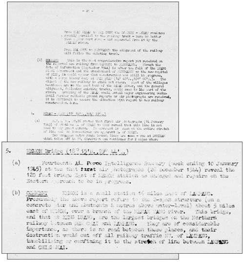
MEMOH Bridge (18°15’N 99°44’E)
(a) Fourteenth Air Force Intelligence Summary (week ending 10 January 1945) states that first air photographs (20 December 1944) reveal the 120 foot bridge east of MEMOH station as damaged and repairs on the eastern approach to be in progress.
(b) COMMENT MEMOH is a small station 16 miles east of LAMPANG. Presumably the above report refers to the 2-span structure (on a concrete pier and abutments 4 meters above water-level) about 5 miles east of MEMOH, over a branch of the MENAM WANG river. This bridge, and that at KENG LUANG, are the largest bridges on the northern railway between DEN CHAI and LAMPANG. They are of considerable importance, as there is no road between these places, and their destruction would cut off all railway traffic NW of LAMPANG, immobilizing or confining it to the stretch of line between LAMPANG and CHIANGMAI.
The bridge’s length of 120 ft (37m) matches the westerly two (~120 ft (36.5m) of the actual three spans: perhaps in that remote area, the easterly most truss had been overshadowed by forest regrown more than 20 years after track installation. Other details mesh well. The bridge, or at least an approach, had been damaged; it was about 21 miles (16+5) east of Lampang; and it was the second largest bridge between Den Chai and Lampang.
The length of the comment above and its detail suggests that the report publisher, Inter-Service Topographical Department (South East Asia Command (SEAC)), wanted to tie down as firmly as possible the location of a bridge too long elusive.
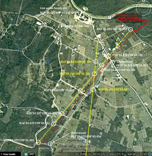
In the Google Earth view below, the bridge is located in relation to the WWII Mae Mo Airstrips: 25
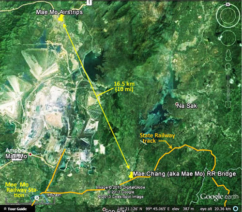
Here a closer view shows how the bridge is located with regard to the similarly named railway station: 25
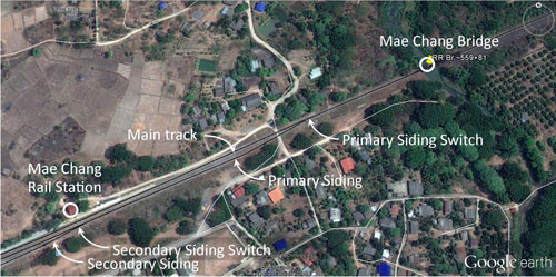
And this yet closer view of the bridge allows the addition of dimensions: 26
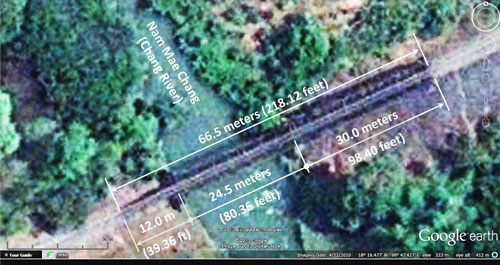
The measurements above do not compare at all well with the USAAF’s reported 120 foot (36.60m) dimension, unless there had been a sequence of errors: possibly the total length of the bridge was scaled at 210 feet (instead of 218) and the numbers were then reversed (210 to 120). The designation of “two span” for three is easier to explain since the westerly span could easily be merged visually from above with the middle span. 27
On the ground, the bridge is seen to be three spans: three distinctly different structures, from east to west (from right to left in the aerials just above):
1. A 30.0m long, eight panel Warren pony-truss with sway bracing and no identification plate, only a cast plate on the east entry portal stating a weight limitation, “15MT”: 28
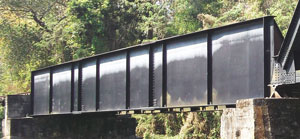
2. A 24.5m “half-through” reinforced girder with a manufacturer’s plate dated 2517 (1974) identifying:
Contractor: Osaka Koza (Thailand) Co, Ltd
Manufacturer: Takigami Steel Construction Co, Ltd, Handa, Japan: 29
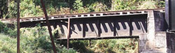
3. A 12.0m deck plate girder without identification: 30
What damage, if any, might have been inflicted on the bridge during the war is unclear. The 2517 (1974) date on the middle span identifies a period when the State Railway of Thailand was upgrading structures as necessary to carry 15 MT. While the middle span was obviously replaced in that program, it is unclear if the two end spans were replaced. What with changing design standards and methods of analysis, during that same period a structural reanalysis might have determined one or both spans not to require replacement; or reinforcement of the existing structures to be sufficient. If such were the case, it is relevant to note that no damage or repairs possibly due to WW2 are obvious. Further, it is probable that span lengths probably did not change; ie, the original abutments and piers were found satisfactory and were (re)used “as is”. 31This would strengthen the argument that Allied intel in reporting a bridge length of 120 feet was in error.
Last Updated on 12 February 2024
- รายงาน การ สําร จอขุดค้น ตาม โครงการ คึกษาเชิงอนรักษ์แหล่งฝังศพทหารญี่บุน สมัย สงครามโลกครั้งที่ 2 จังหวัดแม่ฮ่องสอน หัางหุ้นส่วนจํากัดเฌอกรีน [Report on Archeological Research for the Japanese Soldiers Burial Project-World War II Era in Mae Hong Son Province], (Chiang Mai: Archaeology & National Museum Office 6, 1999), p 35. Unique among the images in the report, only this one is unattributed. Hence, I don’t know where to look for a better copy, or how to date it or determine its direction of view. The title of the museum report specifies Mae Hong Son Province. Why this photo of a site in Lampang Province, two provinces to the east of the subject province, is included in this report is unclear.[↩]
- Mae Mo Airstrip location per Sakpinit Promthep: N18-25 E99-45 (via Jack Eisner email of 09 Jan 2010).[↩]
- Photo is extracted from DSCF1599.jpg, 25 Jul 2013. Shopkeeper/shop owner: Sawai Maneesarn Moo 7, Tambon Ban Dong Amphoe Mae Mo, Chungwat Lampang. นายเสวย ทวีสาร บ้านหมู่7 ตำบลบ้านดง อำเภอแม่เมาะ จังหวัดลำปาง[↩]
- DSCF1592.jpg of 25 Jul 2013.[↩]
- DSCF1610.jpg of 25 Jul 2013.[↩]
- Portion of image attributed in footnote 24, with additional annotations by author using Microsoft Publisher.[↩]
- DSCF1602.jpg of 25 Jul 2013. Coordinates of shell crater (diameter 8m) shown: N18°24.747 E99°43.661 Coordinates of shell crater (diameter 13m) not shown: N18°24.674 E99°43.573 [Coordinates added: 01 May 2014].[↩]
- DSCF1613.jpg of 25 Jul 2013. Building front faces approximately north.[↩]
- DSCF1619.jpg of 25 Jul 2013[↩]
- DSCF1615.jpg of 25 Jul 2013.[↩]
- Jack Eisner recounts hearing a similar story at a far distant, unrelated location; point being, the spirit world continues to be a very real factor in the outlook of some Thais.[↩]
- Google Earth view of Mae Mo location and “show elevation profile” activated.[↩]
- Google Earth image enhanced with IrfanView and annotated with Microsoft Publisher by author. Location coordinates per Google Earth.[↩]
- Railway stationing per Wisarut [Bholsithi] in 2bangkok forum topic, “Ban Chang Railway Bridge, Lampang Province”(#2), 13 Feb 2014. The title was incorrect: it should have been Mae Chang, or, less correctly, Ban Mae Chang. Unfortunately, the thread was not restored after the site was destroyed by hackers.[↩]
- ibid.[↩]
- Coordinates per Google Earth.[↩]
- BR Whyte, in The Railway Atlas of Thailand, Laos and Cambodia (Bangkok: White Lotus, 2010), shows no major bridge in that stretch of track (p 28). He specifies elsewhere (p xiii) that he lists only “major bridges” (emphasis mine), which would appear to include only structures with lengths of at least 100m. There are lesser (simple span) bridging structures in the 95 km between the Kaeng Luang Bridge and Lampang, some of which are visible via Google Earth; 21 bridge symbols can be counted on Royal Thai Survey Department maps 4845 I and 4945 I thru IV which cover that length of railway. [«6æ][↩]
- 21PRS Report Mission No. 4 MA 115, 18 Sep 1944 (USAF Archive microfilm reel A0878 p0441). [«6a][↩]
- Pakhem no longer exists — it has been absorbed by the sprawling Mae Mo lignite surface mine whose product powers the Mae Mo Power Generation Plant. However, somewhat humorously, both mapquest (at N18°20.13 E99°43.90) and Satellite Views (at N18°20.15 E99°43.92) list the location. The coordinates compare reasonably well with the photo order’s N18°20 E99°48. The latter Internet source further describes Pakhem as a “City or Community: Populated place”. [«6a1].[↩]
- 21PRS Report Mission No. 4 MA 118, 22 Sep 1944 (USAF Archive microfilm reel A0878 p0476). [«6b][↩]
- 21PRS Report Mission No. 4 MA 132, 25 Oct 1944 (USAF Archive microfilm reel A0878 p0551). [«7a][↩]
- Road and Railroad Communications Report: Asiatic Area, “Siam – Roads & Railroads”, p 37 (two dates appear: 25 Oct 44 and 01 Nov 44) (Joint Intelligence Collection Agency, 01-15 Dec 1944) (USAF Archive microfilm reel A8044 p0416). [«8].[↩]
- Courtesy of Tony Strotman (mgr, website,
341st Bombing Group).
491st Mission C-241; Kenghluang Bridge; (Summary of narrative on Mission Report).The report incorrectly placed the Kaeng Luang bridge in Indochina (another report had put it in Burma — regardless, the coordinates of the bridge were accurate, unlike many of those used in reports about the Mae Chang bridge).
Strotman cautions:
Comparing USAF Chrono dates with Mission Report dates for 341st BmGp squadrons indicates to me that some, tho definitely not all, chrono dates for CBI have been adjusted for dateline difference to reflect the America equivalent date; ie, Chrono date = CBI date minus 1.
In this instance, an editor bobbled the formula and redated the event on 26 Nov rather than 24 Nov. [«12].[↩]
- Communications in Siam, French Indo-China & Yunnan: A Monthly Summary, Part I Siam: Railways Inter-Service (?: Topographical Department (South East Asia Command (SEAC), 01 Mar 1945), p 20 (USAF Archive microfilm reel A8021 p0178).
Coordinates given for a “Memoh Bridge”, N18°15 E99°44 are not close to any significant feature. The point is about 2 km south of the rail track and 3 km ESE of Mae Mo Rail Station.
Note: weeks ending 10 Jan 1945 & 20 Dec 1944=Wed. So weekly reporting periods were Thursday through Wednesday.
The tributary to the “Menam Wang river” would be the Nam Mae Chang. Coordinates at stream center under bridge: N18°16.476 E99°47.426 (quite a contrast to the reported N18°15 E99°44).
As noted before, Whyte does not list the bridge. A previous intel description of the site which included mention of a siding is consistent with the sidings at the Mae Chang station.
The details, “on a concrete pier and abutments 4 meters above water level”, suggest either the existence of an excellent quality oblique photo of the bridge, or an on-the-ground intel source, or possession of plans for the bridge. [«12a].[↩]
- Google Earth image enhanced with IrfanView and annotated with Microsoft Publisher by author.[↩][↩]
- Google Earth image enhanced with IrfanView and annotated with Microsoft Publisher by author. Lengths per Wisarut [Bholsithi] in 2bangkok forum topic, “Ban [Mae] Chang Railway Bridge, Lampang Province”(#2), 13 Feb 2014. The thread was not restored after the site was destroyed by hackers.[↩]
-
Admittedly this is pure speculation; and it is not consistent with the detailed reporting of the foundations of the bridge above which imply either eyes “on the ground” or a good oblique aerial photo broadside of the bridge.
Note also that the length of the Mae Chang bridge is incorrectly recorded in the rotfaithai listing, Stations and Stops in Thailand, as 25m, while it is actually 66.5m±. The recorded distance of 25m covers the plate girder structure spanning just the stream; ironically the more prominent steel truss in the three span bridge is longer at 30m, but it does not span the stream proper.
[↩]
- Looking NNW; extracted from DSCF1671+1672_stitchaa.jpg of 02 Feb 2014 joined by Microsoft ICE; enhanced with IrfanView. Length scaled from Google Earth.[↩]
- Looking northwest; extracted from DSCF1680b.jpg of 02 Feb 2014; enhanced with IrfanView. Length scaled from Google Earth.[↩]
- Looking WNW, extracted from DSCF1694+1695-west-span.jpg of 02 Feb 2014; joined by Microsoft ICE; enhanced with IrfanView. Length scaled from Google Earth.[↩]
- Program to upgrade SRT structures circa 1974 and span length probably unchanged per Wisarut [Bholsithi] in 2bangkok forum topic, “Ban [Mae] Chang Railway Bridge, Lampang Province“(#4), 13 Feb 2014. The thread was not restored after the site was destroyed by hackers.[↩]