Major Sources
Summaries of Japanese text translated from
Journal on Collection of Japanese War Dead: Burma, India, Thailand1
Schedule
08-23 Nov 1977 — Phase I: Investigation
17 Jan – 07 Feb 1978 — Phase II: 1st Collection Effort
07 – 22 Mar 1978 — Phase II: 2nd Collection Effort
An Outline of Scorched Bones2
May 1975. Japan’s Ministry of Health and Welfare began a study about the retrieval of remains of Japanese personnel who had died in Thailand, as well as the remains of those who had fallen in battle in Burma and been transported back to Thailand near the end of the war. . . .
Several groups of soldiers and units under the command of the 15th (Forest) Army [while retreating south from the failed attempt to invade India] towards Moulmein passed through Kemapyu [today’s Khe Hpyu]. There they ordered their wounded, as well as weakened soldiers judged not able to handle the forced march through the mountains, to convalesce at Kemapyu and then head east into Thailand. About 5,000 patients eventually traveled to Thailand from Kemapyu. . . . , plus an estimated 20,000-30,000 troops from the Dragon [56th] Division and various other army units which had attached themselves to the Dragon Division.
[Kemapyu in Burma is at about the same latitude as Khun Yuam in Thailand. However, the roads/trails connecting the two dip well south to Mese Atet, Burma in order to thread up the Hwe Namman (river) valley through the Dawna Mountain Range to Dan Huai Ton Nun (Thailand’s Border Post 13 (N18°46.54 E97°45.18)] and then easterly to Khun Yuam.]
. . . [IJA troops coming from Kemapyu] entered Thai territory and at Khun Yuam branched off to one of three routes to Chiang Mai:3
[1] Northern via Mae Hong Son and Pai: 317 km4
[2] Central
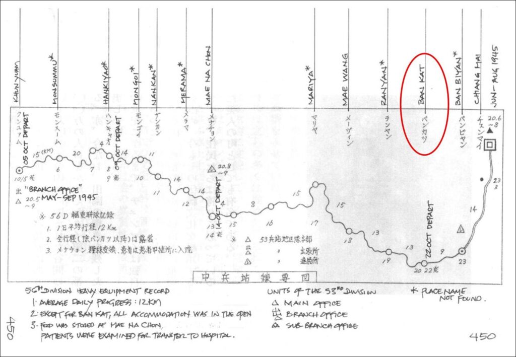
• via Mae Na Chon and Ban Kat: 197 km5
• thru Doi Inthanon NP: 235 km6
• via Mae Chaem & Ob Luang NP: 274 km6
[3] Southern via Mae Sariang: 353 km7
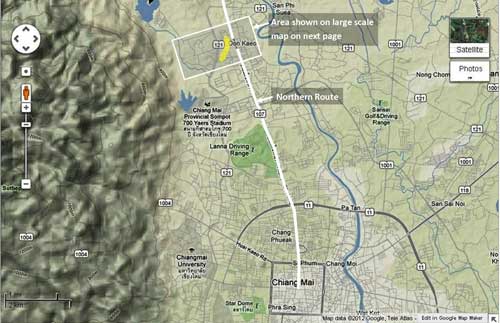
Patients / walking wounded were sent via the northern route because it had fewer steep slopes and a greater number of waypoint stations than the very mountainous (but shorter) central route. In any case, patients generally went north, and [reasonably] graves are by far greater in number along the northern supply route. For those in fairly good physical condition, the central route was a reasonable alternative, but the majority of personnel apparently followed the northern route. It should be noted that some elected not to go over the mountains to Khun Yuam, but rather angled down to Mae Sariang to pick up the less well-marked southern route through Hot. [pp 419-422]
Central Military Supply Line
Compared to the Northern Line, the Khun Yuam – Mae Na Chon – [Ban Kat] – San Pa Tong Central Military Supply Line is only about 60% of the distance, so those who were in a hurry or those who had confidence in their leg strength had chosen this route. The mountains were persistently steep, and it was quite certainly a journey of hardship. . . .
It was said that Japanese people occasionally stopped in Ban Kat. Among those were Japanese whose purpose was unknown, but an old man said that there were many who came to reminisce about the war. This man was particularly concerned about helping the investigation group, and even though he was 80 years old, he showed us around by himself. He gave us his house and welcomed us warmly. . . .
. . . The village chief of Mae Na Chon during the war, and who we interviewed in Ban Kat, gave us specific and very useful information about the situation there at that time:
1) Japanese soldiers who had come were relatively healthy, and they had rested at this village for a few days before heading off on the eastern mountain road toward Chiang Mai. . . .
6) Near the end of the war, on average once a week, a group of soldiers would pass by on its way to Chiang Mai.
. . . We reviewed the information we had about Ban Kat, what lay beyond to the west, and our schedule, and we abandoned the objective of investigating the mountain crossing. Those individuals who took the Central Supply Line are thought to have been of the “Dragon” or attached forces, and it is assumed that they were in good physical condition because of their participation in many group maneuvers. It is thought that those who needed medical support after leaving Khun Yuam were well enough to get to Mae Na Chon, where medical services were available; similarly, those who fell ill after Mae Na Chon were able to get to medical facilities at Ban Kat.
The collection group took Ban Kat as its main focus, and tried to do what was possible at the burial site in Mae Na Chon. Along the route connecting the two, with no inhabitants and hence no information, collection was impossible. At Ban Kat in a bamboo grove of about 1300 sq meters,8 reported to have been a field hospital site, remains were collected. Of course, remains were not complete because smaller skeletal parts had disintegrated.
Ban Kat held the [remains of 63],9 but unfortunately behind places like Mae Win,10 collection could not be done. During the second day of the Ban Kat collection, a group led by former Minister of Health and Welfare Watanabe visited us at the site to give encouragement, and the former minister himself dug with a shovel and uncovered seven bodies. [pp 450-453]
. . . Group Leader Inoue recorded: The report of the investigation division estimated 129 bodies [east of us]. Most of these, 90%, were in Ban Kat and Mae Na Chon on the Central Military Supply Line. [p 459]
Thailand War Dead Remains Collection Results Chart
. . . Chiang Mai Province
Location: San Pa Tong
Area: Ban Kat
Total: 63
[p 470]
From Report on Archaeological Research for Japanese Soldiers
Burial Project World War II Era – Mae Hong Son Province11
This Thai language reference focuses on Mae Hong Son Province. Though Ban Kat is on the trail from Mae Hong Son (specifically Khun Yuam) to Chiang Mai, it is mentioned only as an intermediate point on the Central Supply Route.
- 戦没者遺骨収集の記録 ピルマ・インド・タイ [Journal on Collection of Japanese War Dead: Burma, India, Thailand (Tokyo: All Burma Comrades Organization, 1980] [↩]
- Translator note: Literally bones gathered either from a battlefield or after cremation [↩]
- Distances noted by the Journal in the late 1970s are compared, when possible, with current distances as determined by Google Maps. Reasons for the substantial differences are not clear. [↩]
- compare 388 per Google Earth now: Khun Yuam to Mae Hong Son, 67 km; on to Pai, add 192 km; finally to Chiang Mai, add 129 km [↩]
- compare 207 km, Khun Yuam to Mae Nachon, 115 km; on to Ban Kat, add 36 km [↩]
- choice of routing unclear [↩] [↩]
- compare 246 km per Google Earth now: Khun Yuam to Mae Sariang, 97 km; on to Hot, add 72 km; finally to Chiang Mai, add 77 km [↩]
- ~400 tsubo (2400 square shaku or 1322.4 square meters). [↩]
- ie, the 55 remains recovered by the 1st search group, and the 8 by the 2nd search group. [↩]
- メーヴィン, ie, assumed to be メブイン [↩]
- รายงาน การ สําร จอขุดค้น ตาม โครงการ คึกษาเชิงอนรักษ์แหล่งฝังศพทหารญี่บุน สมัย สงครามโลกครั้งที่ 2 จังหวัดแม่ฮ่องสอน หัางหุ้นส่วนจํากัดเฌอกรีน [Report on Archaeological Research for the Japanese Soldiers Burial Project World War II Era – Mae Hong Son Province (Chiang Mai: Green Tree, LLP, Ltd, submitted by / for Mae Hong Son Province Archaeology National Museum Office 6, Chiang Mai, 1999)] [↩]
