 RAF B24H EW174 under attack near Nakhon Sawan1
The core for this webpage is a 13 page “easy-read” written by Harry Smith, et al, survivors of the EW174 crash: Escape from Siam (offsite link to the Wayback Machine), and is highly recommended as an introduction.
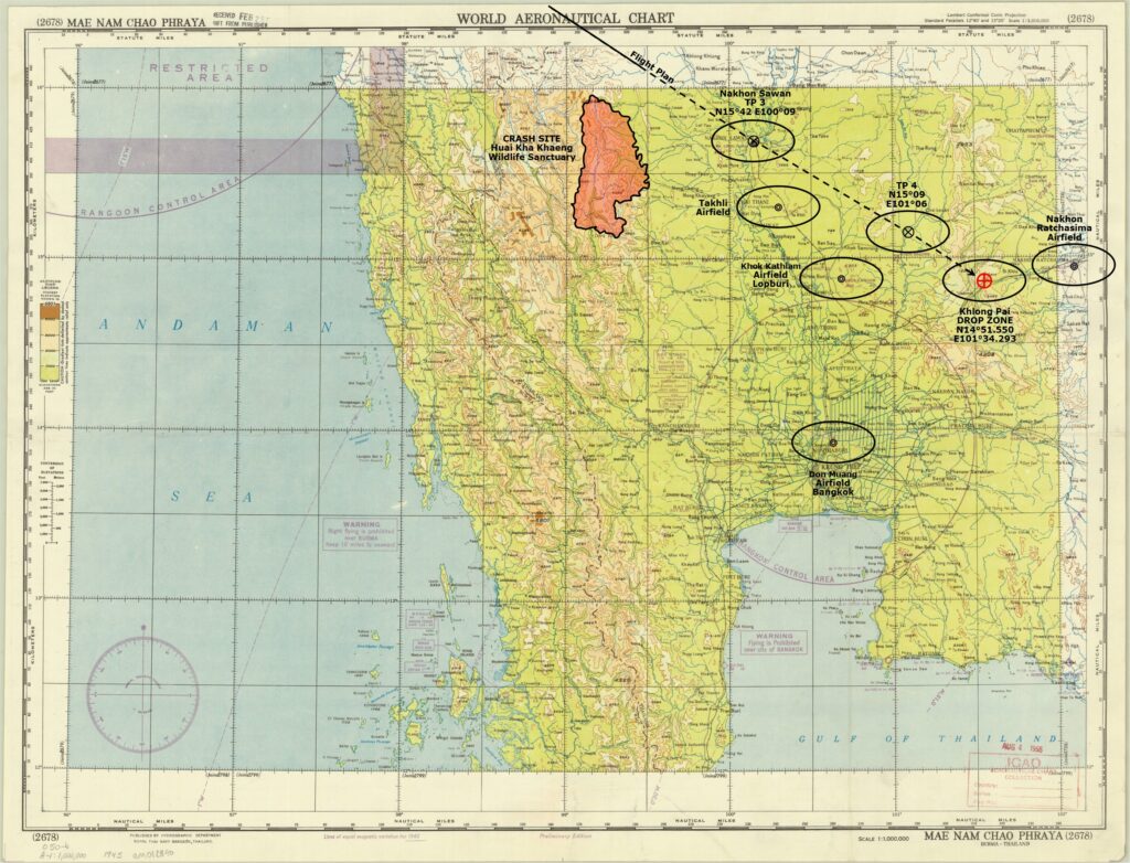
29 May 1945: RAF 358 Squadron (offsite link), based in Jessore Airfield2 (Google Maps link), India, and equipped with B-24 Liberator Mark VI bombers by this date, was tasked with “special duties” (earning the squadron the suffix “SD”, as a result). Those duties concentrated on support for Free Thai units which were sponsored by British and American intelligence units (British Special Operations Executive (SOE) Force 136 and US Office of Strategic Operations (OSS), respectively). On this date, 358 Squadron Liberator VI, EW174 (designated ‘P’), was tasked with delivering OSS agents and supplies by parachute to a jungle position in Khlong Phai Subdistrict3 (Google Maps link), just west of Nakhon Ratchasima (Korat) in Thailand.
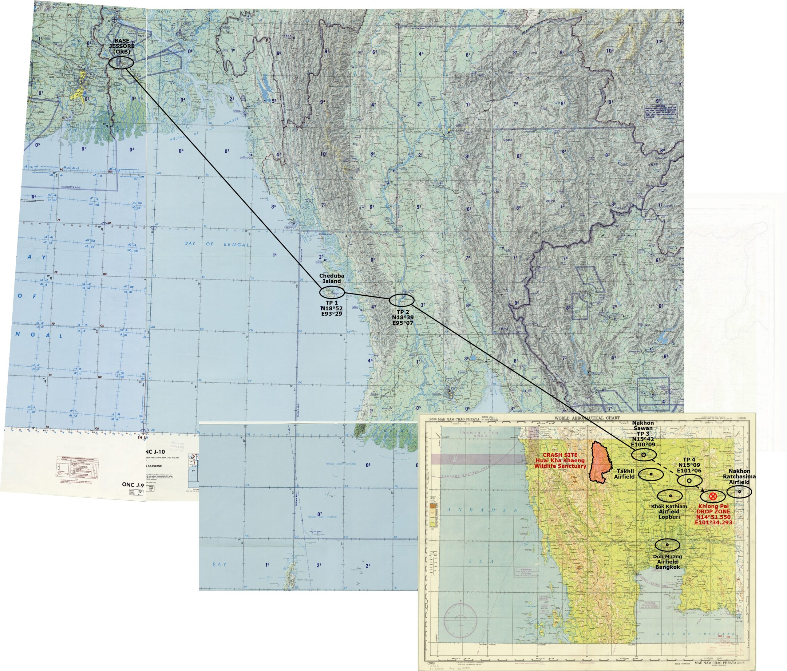
The RAF Operations Record Book outlined the flight by turning points (TPs) as:4
![]()
Transcript, with comments added:
| Name . . Distances |
|||||
| BASE | Jessore | ||||
| 367 nm Σ367 nm |
|||||
| TP 1 | Cheduba Island | ||||
| (⇒ | (added) | – | ACTUAL DAWN |
– | 4:17 4:40) |
| 84 nm Σ451 nm |
|||||
| TP 2 | Irrawaddy River | ||||
| 338 nm Σ789 nm |
|||||
| TP 3 | Nakhon Sawan | 06;30 | |||
| (⇒ | (added) | – | DAWN (PLANNED) | 4:17 4:40 |
–) |
| 64 nm Σ853 nm |
|||||
| TP 4 | near Lopburi | ~ | |||
| 33 nm Σ886 nm |
|||||
| DZ | Khlong Phai area | ~ | |||
| And return same route | |||||
The route is plotted here, using 1980s-era Operational Navigation Charts (ONCs) merged with a 1945 Royal Thai Navy aeronautical chart for the Drop Zone area:5
The mission orders included “Your takeoff time is 00:00 hours to place you over the DZ at dawn”. The term, “dawn”, seems straightforward, but it turns out to have been open to interpretation. Practically speaking, it could cover a 23 minute period from 05:24 to 05:47.6
Time Zone(s)
A problem immediately arises as to what / which time zone(s) was / were being used in the various texts describing EW174 events: the Calcutta area was officially using “Calcutta Time” (UTC+5:53) until 1948, whereas most of India (“British India”) had adopted IST (UTC+5:30) back in 1905.7 The target area was in the Bangkok Time Zone (UTC+7). As a consequence, any moment in equivalent Calcutta (clock) time, at UTC+5:53, would lag time in the drop zone by 1 hr 07 min. For discussion here, it is assumed that those aircrew members with wristwatches8 would have kept them on Calcutta Time; hence all times mentioned in Escape from Siam are assumed to refer to Calcutta Time.
Takeoff Time (00:00)
Accounts varied as to takeoff time:
- ~2230: Shortly after 2230 hours (Pugh)
- Midnight: “Take-off was scheduled for midnight” (Smith)
- 00:00: “Your takeoff time is 00:00 hours to place you over the DZ at dawn.” (Pre-flight briefing per Smith)
- 00:04: RAF Operations Record Book
- 00:05: “we finally took off at 5 minutes past midnight” (Roe)
For ease of calculation, an approximate midnight departure appears to prevail. Leaving at midnight (Calcutta time), with a cruising speed of 187 knots,9 an uninterrupted flight from Jessore to Khlong Phai, 886 nm,10 would take 4 hrs 44 min. That would convert to a local arrival (Bangkok) time at the target (Khlong Phai) of 5:51 (4:44 + 1:07 (UTC+7) ), four minutes after a nominal sunrise at Nakhon Sawan on that date, in local time, of 5:47.11 Excellent timing, except that it was for an idealized, uninterrupted flight of 886 nm.
First leg of flight (planned 00:00-01:58, actual 00:00-04:15)
The recorded duration of the first leg of the flight, from BASE (Jessore) to TP1 (Cheduba Island; ie, Burma border), introduces problems. The distance 367 nautical miles (nm), at a flight speed of 187 knots, should have taken 1 hour 58 minutes: starting at midnight (00:00), EW174 would have arrived at TP1 at 01:58. However, the narrative records the plane crossing the Burma shore around 04:15 hours, ie, 2 hours 17 min after it had been planned. I assume here that the crew continued observing events in Calcutta Time, which means that the plane flew for 4 hrs 15 min, presumably at 187 knots, covering 795 nm, more than twice the staight-line distance in that first leg. These factors could have increased flight time / distance:
- Weather per Pugh: “It was quite bumpy and raining heavily as well. Out over the Bay of Bengal Smithy decided to come down to 500 ft in order to miss the heavy clouds above and ahead of us. . . The poor weather and being knocked about in the sky did not make any of us feel like singing although we usually did”. . . . (Smith, et al, p 3)
[The eastern leg of the Southwest Monsoon normally begins at Kerala in June and moves northerly up the Bay of Bengal, bringing rains to eastern India (and points north), lasting until September.12 Smith offered no observations regarding headwinds encountered.Reynolds (p 335) noted, “the necessity to evade storms along the route put [the flight] behind schedule.” - Smith did recall from other night flights, “The blackness of night . . . enabled us to penetrate the monsoon weather fronts by flying between the lightning flashes emitting from the ever-present cumulonimbus clouds” (Smith, et al, p 1). The moon had been full two nights before,13 so the night was not black (at least, above the clouds). Regardless, any resultant zigzagging tactic on this flight would have increased distance/time, but Smith did not mention using this tactic in this flight].
Whatever the reason(s) for the extended flight time between Jessore and Cheluba, the end result: EW174 was significantly behind schedule: continuing with Calcutta time: 01:58 scheduled arrival at TP1 vs 04:15 recorded arrival made the flight 2 hrs 17 min late. That error would have persisted through the rest of the flight.
Second leg of flight (planned 01:58-02:25, actual 04:15-04:42)
Presumably before reaching the Burma coast at 04:15, Smith would have begun to climb from 500 feet to clear mountain elevations inland from the western Burma coast shown on TPC J-10C as maxing at 7200 feet, so EW174 might have climbed to, say, 10,000 feet (which, at 1,025 ft/min climb rate,14 would have taken about 10 minutes) which might also have added to flight time.
During this leg, the period of dawn as outlined above, between 04:17 and 04:40, would have started almost immediately after reaching Turning Point 1. Hence the flight had passed into “daylight” before finishing the second leg of flight at 04:42.
Third leg of flight (planned 02:25-04:13, actual 04:42-06:30)
“At 06:30 with the coastal mountains far behind, we began a descent to reach 500 ft. at the DZ in Siam. . . .” This would seem to have been around Turning Point 3. The distance from TP 1 to TP 3, 84+338, or 422 nm, at 187 knots, should have taken 2 hrs 15 min. This coincides nicely with the flight time from TP1 (Cheduba Island), starting at 04:15, and ending over TP3 (Nakhon Sawan) at 06:30.
At the end of the third leg, 06:30, the sun had been “up”, above the horizon, for almost two hours. Fine details, affecting the start of the dawn period, less than five minutes, due to atmospheric refraction and aircraft altitude, would have been insignificant.15
In view of the above,
- Smith’s observation that “The sun was rising earlier than expected” (Smith, p 3) is puzzling. The hour of dawn had been recognized in the original flight plan. But, for reasons not clear, the first leg of the flight had taken 04 hrs 15 min instead of 1 hr 58 min putting EW174 1 hr 50 min behind schedule which forced him well into “daytime” by TP3.
- Smith noted further that “. . . for the first time in 1 1/2 years the sky was completely clear. Wall to wall CAVU (ceiling and visibility unlimited)”: this was also perplexing, for in central Thailand, the hot, dry season, noted for air pollution stoked by the burning of rice paddies ends with the coming of rain typically in mid-May with clear atmosphere following.
On top of all this, Smith seemed unaware that Allied Intelligence in mid-May had identified a concentration of 5,000 Japanese with 80 to 90 aircraft at Takhli, about 150 km west of the DZ, but only about 30 km south of EW174’s planned flight path.16
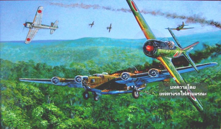
At approximately 06:30, nine IJAAF 64th Sentai Ki-43s had completed dropping medical supplies to IJA troops who had retreated from Rangoon into the jungle along the Thai-Burma border. During their return to their home base in Takhli, the Japanese flight spotted EW174 heading ESE, about 100 nm (185 km) shy of its DZ. Sgt Toshimi Ikezawa recalled that the bomber proved easy meat for the Ki-43 pilots;
. . . we’d often catch B-24s dropping personnel into the jungle by parachute. We’d line up astern of the bombers to make our attacks by the book, usually with two or three passes.
EW174, stripped of most of its armament to maximize payload, was, as described by Ikezawa, “easy meat”. The nine Ki-43s shot out all four engines of the B-24, forcing Smith to crashland in the jungle.
CRASH DOCUMENTATION
From The RAF Operations Record Book:4
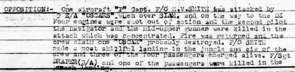
Transcript, with comment:
OPPOSITION:- One aircraft “P”17 Capt F/O [Flight Officer] HV SMITH was attacked by 9 E/A [Enemy Aircraft] “OSCARS” [Ki-43s] when over SIAM, and on the way to the DZ [Drop Zone], four engines were shot out of action and the second pilot, the navigator, and the mid-upper gunner were killed in the attack which was concentrated. Fire was returned and the crew claim one “OSCAR” probably destroyed. F/O SMITH made a most skillful landing in the jungle and six of the crew and three of the four passengers emerged alive. F/Sgt [Flight Sargent] DRAPER(?/), and one of the passengers were killed in the crash landing.
and
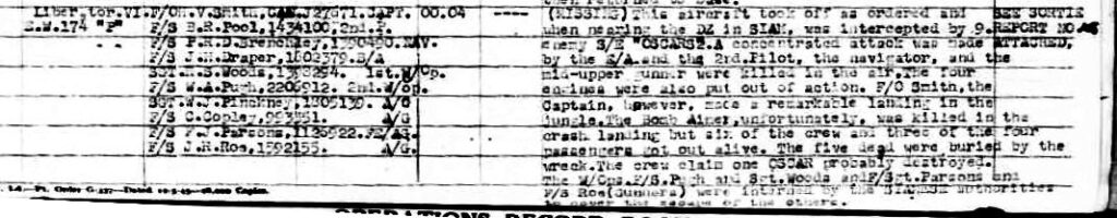
Transcript, with comment:
Crew:
F/O MV Smith CAN J27671, CAPT [survived]
F/S BR Pool, 1434100, 2nd P[ilot] [mortally shot in flight]
F/S PRD Brenchley, 1390490 NAV[igator] [mortally shot in flight]
F/S JH Draper, 1802379.B/A [Bomb Aimer] [killed in landing]
SGT RS Woods, 1398294. 1st W/Ops [Wireless Operator] [survived]
F/S WA Pugh, 2206912. 2nd W/Ops [Wireless Operator] [survived]
SGT WJ Pinckney, 1805139. A/G [Gunner] [mortally shot in flight]
F/S C Copley, 993551. A/G [Gunner] [survived]
F/S FJ Parsons, 1126922. FE/AG [Flight Engineer/Gunner] [survived]
F/S JR Roe, 1592155. A/G [Gunner] [survived]
Time
Up [takeoff]/Down: 00.04 / —- [not recorded]
Details of Sortie or Flight:
([Status] MISSING) This aircraft took off as ordered and when nearing the DZ [Drop Zone] in SIAM, was intercepted by 9 enemy S/E [Single Engine] “OSCARS”[Ki-43s]. A concentrated attack was made by the E/A [Enemy Aircraft] and the 2nd Pilot [co-pilot], the navigator, and the mid-upper gunner were killed in the air. The four engines were also put out of action. F/O [Flight Officer] Smith, the Captain, however, made a remarkable landing in the jungle. The Bomb Aimer, unfortunately, was killed in the crash landing but six of the crew and three of the four passengers got out alive. The five dead were buried by the wreck. The crew claim one OSCAR probably destroyed. The W/Ops [Wireless Operators] F/S Pugh and Gunners, Sgt Woods and F/Sgt Parsons and F/S Roe were interned by the SIAMESE authorities to cover the escape of the others.
Tallied in the book, Escape from Siam, but not listed in RAF report, were the OSS “passengers”:
-
-
- Major Gildee [survived]
- Lt. Reid Moore [survived]
- McCarthy [survived]
- Cpl Naparolski [died from injuries shortly after landing]
-
In brief, the dead were buried near the crash, and the survivors were escorted by friendly Thais to Bangkok where the pilot and one crewman (Copley) plus surviving OSS members were eventually smuggled out to India by a 356 Squadron DC-3. Their “escape” from Thailand was wholly engineered by Allied forces in place in Bangkok. The remaining crewmembers were put in a Thai-controlled POW camp from which they were freed about two months later with the end of the war.
REFERENCES (in alphabetical order by author)
Ichimura, Hiroshi, Ki-43 ‘Oscar’ Aces of World War 2 (Oxford: Osprey, 2009), “53%” (epub, unpaginated) briefly described the air combat:
After the 26th Indian Division captured Rangoon on 1 May, 64th Sentai Ki-43s dropped medical supplies to Japanese troops who had retreated into the jungle on the Burmese-Thai border. At this time the unit was based at Takhli airfield, 90 miles north of Bangkok. Chiang Mai, Lampang and Nakhon Sawan were used as advanced airfields.
At dawn on 29 May [1945], nine Ki-43s flew from Nakhon Sawan to Takhli. They had completed the unit’s last air supply mission in the border area and were heading home when they sighted a Liberator III of No 358 Sqn dropping supplies to insurgent forces. Sgt Toshimi Ikezawa recalled that the bomber proved easy meat for the Ki-43 pilots;
‘Flying over Thailand in groups of about ten aircraft, we’d often catch B-24s dropping personnel into the jungle by parachute. We’d line up astern of the bombers to make our attacks by the book, usually with two or three passes. . . .
This Liberator was the 64th Sentai’s final victory, and its loss is confirmed by Allied records.
[The book does not mention the loss of a Ki-43 during the attack.]
Ozel, Steve 18
29May45
Liberator B.VI RAF
358 Sqdn EW174 / P
Shot down NW of Nakhon Sawan (estimated to be at 16.500590°, 99.331485°)19 on a mission to deliver OSS agents to a jungle location;
5 killed:
Killed by enemy aircraft gunfire in flight:
Flt Sgt Brian Richard Poole
Flt Sgt Peter Reginald Dann Brenchley
Sgt William John Pinckney
Killed during crash landing: Flt Sgt John Henry Draper
Died shortly after crash: US Army Cpl Napieralski
8 survived, although some injured:
OSS agents:
Maj J Gildee
Lt RS Moore
Sgt EJ McCarthy
plus crew members:
Sgt RS Woods
Flt Sgt C Copley
Sgt FJ Parsons
Flt Sgt WA Pugh
Sgt JR Rowe
[Note that the pilot, Flight Captain Harry Smith, was inadvertently omitted from the crew list; so nine total survived]
Reynolds, EB, Thailand’s Secret War (Cambridge, University Press, 2005), p 335 [emphases mine]
. . . second OSS effort to insert a team of guerrilla trainers into the provinces on 29 May proved disastrous. A British B-24 had been scheduled to reach the drop zone in the YIELD area near [Khlong Phai] (between Lopburi and Khorat) at dawn, but the necessity to evade storms along the route put it behind schedule.
[footnote 13] . . . The Allies were aware of an increased Japanese presence at Takli. An intelligence report from mid-May (Folder ZM-139, Box 386, Entry 108, RG 226) reported 5,000 Japanese personnel and eighty to ninety aircraft at the facility.
Rowe, JR, BBC: WW2 People’s War Shot down in Siam, May 1945 (offsite link), an interview with JR Rowe, one of the survivers, offers more information about the EW174 crash.
Shores, Christopher, Air War for Burma (London: Grub Street, 2005), p 367 [emphasis mine]
Shores summarizes the event, including the detail that the B-24 gunners may have downed one of the attacking Ki-43s. His brevity describes five of the survivors “able to walk out and escape” whereas nine survivors were escorted by a friendly Thai military using cart and boat down to Bangkok where Thai authorities were able to smuggle some out, while sending others to a POW camp.
Smith, Harry, Cyril “Curly” Copley, W. “Timber” Woods, J. “Ramsay” Roe, & W. A. “Bill” Pugh, Escape from Siam (offsite link to a 13 page pdf file). EW174 crashed in enemy territory. In-progress flight records were lost. The navigator, key for position reporting, was killed by enemy aircraft fire. Subsequent debriefings were out of the question. While normal documentation wouldn’t exist for such a flight, several of the survivors cooperated in preparing and publishing an account of the key events in that flight in Escape from Siam and is recommended reading. As to be expected in such stressful situations, individuals’ memories were not altogether reliable. Minor Inconsistencies and contradictions are pointed out and clarifications attempted in the following review of the last flight of EW174.
Umemoto, Hiroshi, ビルマ航空戦・上 [Air War in Burma, Vol 1] (Tokyo: Dai Nippon, 2002)]
Umemoto does not mention the EW174 incident: his chronology ends on 30 April 1945; and, to be fair, his subject is the IJAAF in Burma, not Thailand.
Young, EM, Aerial Nationalism (Washington: Smithsonian, 1995), pp 210-211
Citing Merrick, KA, Flights of the Forgotten (London: Arms and Armour Press, 1989), pp 299-300 which was in error, Young tied EW174 to 357 Squadron not 358, and located the drop zone in Malaya, not Khlong Phai, Thailand.
CRASH SITE LOCATION
From Sakpinit Promthep email 19:25 23 Sep 2021:
I found no report of this B-24 crash so far. However, when I worked with JPAC in 2004 we tried to locate the crash site too. The attempt was canceled when the JPAC [team] found that all remains were recovered. During that time we heard from Tango Sqn that the crash site is in Uthaithani. . . . He told us the site is in HUAI KHA KHAENG WILDLIFE SANCTUARY and the forest officials there know exactly where the site is. It takes a long trek and need to stay overnight in the jungle. The wreck is in a stream and during dry season we may see its two tails out of the water. This is what I heard.
Huai Kha Khaeng Wildlife Sanctuary is perhaps 40 nm southwest of the planned flight path of EW174; at a cruise speed of 187 knots — though course and speed would have varied during EW174’s evasive manoeuvering — the sanctuary represented about 13 minutes of straight-line flight time.
Subsequent information from Sakpinit:20
Recently, there was a[nother] wreck found in that area which may be also of . . . interest. See The wreckage of a Japanese aircraft from World War II has been found in the Huai Kha Khae forest [พบซากเครื่องบินญี่ปุ่นสมัยสงครามโลกครั้งที่ 2 บนป่าห้วยขาแข้.mp4 below (Thai language):21
Facebook link: https://scontent-sin6-1.xx.fbcdn.net/v/t39.30808-6/501196092_1492701341998596_2172474199427009270_n.jpg?_nc_cat=111&ccb=1-7&_nc_sid=833d8c&_nc_ohc=mRYUB7MfAa0Q7kNvwFou394&_nc_oc=AdkB5F6qJwb-naFdUjpW1bkrCRtvIpxdvkCAS3pyWZV3G-y6KPP8L0guq5B2_gLGKuc&_nc_zt=23&_nc_ht=scontent-sin6-1.xx&_nc_gid=30Hjr5Ls1bp9pOpMrGFeKQ&oh=00_Afv1guOyui3ao9G4gzkfn4xpWWIlukbWsch-f4aSW4F–w&oe=69862E63(offsite link no longer active). My ref: \02500 Tango\_Crash sites N TH for Tango\DETAIL SHEETS\A450529 Nakhon Sawan EW174\Media coverage\Smith’s B-24 painting.txt[↩]- N23°11.07 E89°09.64[↩]
- N14°50.9 E101°34.17[↩]
- provided by Stefan Zingg email 01:14 11-Oct-21[↩][↩]
- Diagram of merged charts:
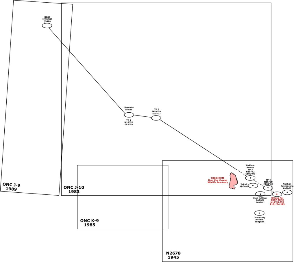
My ref: \02500 Tango\_Crash sites N TH for Tango\DETAIL SHEETS\A450529 Nakhon Sawan EW174\Maps\Location-new.pub, shts 1,3.
ONC J-9: Bangladesh; India: my ref: \bPROJECT\_MAPS\SE ASIA MAPS\Maps not Thailand\BURMA Maps\_Dnlded Sep 2024\TPCs-1M&500K, 1980,90s\ONC J-9 E India txu-pclmaps-oclc-8322829_j_9-1M-1989.jpg
ONC J-10: Bangladesh; Burma; China; India; Laos;Thailand; Vietnam: my ref: \bPROJECT\_MAPS\SE ASIA MAPS\Maps not Thailand\BURMA Maps\_Dnlded Sep 2024\TPCs-1M&500K, 1980,90s\ONC J-10 Bangla, N TH txu-pclmaps-oclc-8322829_j_10-1M-1983.jpg
ONC K-9: Andaman Islands; Burma; Kampuchea; Thailand: my ref: \bPROJECT\_MAPS\SE ASIA MAPS\Maps not Thailand\BURMA Maps\_Dnlded Sep 2024\TPCs-1M&500K, 1980,90s\ONC K-9 S Centr TH txu-pclmaps-oclc-8322829_k_9-1M-1985.jpg
American Geographical Society Library Digital Map Collection; World aeronautical chart, Mae Nam Chao Phraya (2678) Burma-Thailand / published by Hydrographic Department Royal Thai Navy (preliminary) Undated, but handwritten date=1945; <https://collections.lib.uwm.edu/digital/collection/agdm/id/20020> [9206KB]. My ref: \bPROJECT\_MAPS\THAILAND Maps\COLLECTN U of Wisc\2678 Mae Nam Chao Phraya aero cht.jpg[↩]
- Technically, there are three “dawns”, defined by the position of the sun below the horizon (6°, 12°, and 18°) (from Civil Twilight – Civil Dawn & Dusk (offsite link):
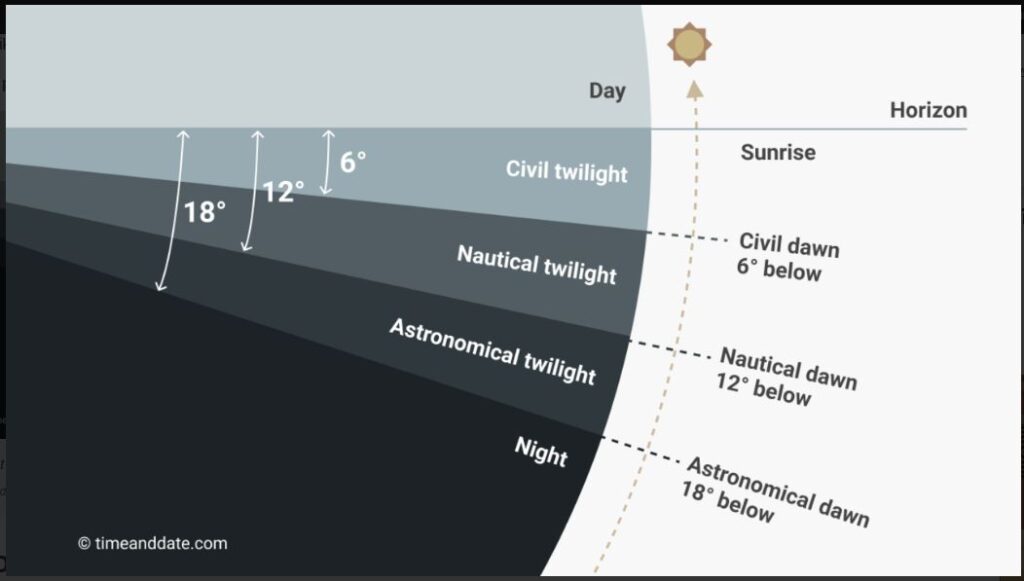
And then there is sunrise itself, whose timing is affected by atmospheric refraction:
Below the astronomical horizon, refraction is so variable that only crude estimates of astronomical refraction can be made; for example, the observed time of sunrise or sunset can vary by several minutes from day to day. As The Nautical Almanac notes, “the actual values of …the refraction at low altitudes may, in extreme atmospheric conditions, differ considerably from the mean values used in the tables.” (Wikipedia: Atmospheric Refraction) (offsite link)
Time-wise, per Nakhon Sawan, Thailand — Sunrise, Sunset, and Daylength, May 2026 (offsite link), these events translate into:
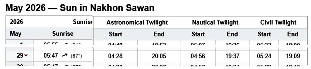
(These events are not available specifically for the Year 1945. Practically speaking, however, there is no variation in these events over the span of years 1945-2026, and so those for the current year are used.)
Civil twilight is the brightest form of twilight. There is enough natural sunlight during this period that artificial light may not be required to carry out outdoor activities. . . . Several countries use this definition of civil twilight to make laws related to aviation . . . .
So “dawn” in the area of Nakhon Sawan on 29 May is assumed to have been sometime after the start of Civil Twilight (05:24), but before sunrise, 05:47 (Nakhon Sawan time: UTC+7). Calcutta equivalent times (UTC+5:53) for that period would have been (1+07) earlier; ie, between 04:17 and 04:40.[↩]
- Wikipedia: Calcutta Time (offsite link) [↩]
- From Wikipedia: History of Watches (offsite link): . . . The British War Department began issuing wristwatches to combatants from 1917. The company H. Williamson Ltd., based in Coventry, was one of the first to capitalize on this opportunity. During the company’s 1916 AGM (offsite link) it was noted that “…the public is buying the practical things of life. Nobody can truthfully contend that the watch is a luxury. It is said that one soldier in every four wears a wristlet watch, and the other three mean to get one as soon as they can.” By the end of the War, almost all enlisted men wore a wristwatch, and after they were demobilized, the fashion soon caught on – the British Horological Journal wrote in 1917 that “…the wristlet watch was little used by the sterner sex before the war, but now is seen on the wrist of nearly every man in uniform and of many men in civilian attire.”[↩]
- Wikipedia B-24 Specifications (offsite link) [↩]
- from Google Earth Pro following the turning points designated for the flight[↩]
- Sunrise in Nakhon Sawan (offsite link) [↩]
- The Indian Monsoon (offsite link) [↩]
- prediopp (offsite link) [↩]
- Wikipedia: B-24 Specifications (offsite link) [↩]
- See TimeandDate (offsite link); note that time will effectively the same for both Years 1945 and 2026.
- Atmospheric refraction might have caused the sunrise to appear two minutes earlier that this.
- Aircraft altitude would have made it appear a few minutes even earlier: “The variation with altitude is approximately linear, and so we conclude that . . . sunrise is earlier by [1 minute for every 1.5 kilometres in altitude], per MattyZ comment of 3:18 14 Feb 2017, “curious.astro.cornell.edu/about-us/161-our-solar-system/… – MattyZ, at 3:18 (offsite link no longer available) ) However, justifying a minimum safe altitude of, say, 10,000 feet or 3 km which would have involved the sun appearing about two minutes before official sunrise.
The five or six minute sum of both additions would not have been significant in comparison to the 1 hr 50 min difference between actual sunrise (04:40 (Calcutta Time) ) at the DZ and the arrival of EW174 (06:30).[↩]
- Reynolds, p 336, fn 13[↩]
- this was a fuselage letter designator assigned to EW174; each aircraft in a squadron received a designator unique in that squadron, per Poole, Matt, Far East RAF Liberators (Yorkshire: Air World, 2025, p 48[↩]
- Thai Air Accidents (offsite link), p 4[↩]
- Stefan Zingg email of 18:31 14 Aug 2021: As for the crash site location, the position given by Steven Darke [Ozel] is surprisingly exactly the same as I marked in a Google-Earth file a few years ago . . . I can’t remember if I have posted it somewhere on the net or not . . . . But it’s possible he got the info from that file. My calculation of the crash site is based on the flight plan (which was not always followed by the pilots) and flying times. It’s only a very rough guess.[↩]
- Sakpinit Promthep email 19:25 23 Sep 2021[↩]
- Former YouTube link: <https://www.youtube.com/watch?v=8RiZMD8iW_E>. My ref: \02500 Tango\_Crash sites N TH for Tango\DETAIL SHEETS\A450529 Nakhon Sawan EW174\พบซากเครื่องบินญี่ปุ่นสมัยสงครามโลกครั้งที่ 2 บนป่าห้วยขาแข้.mp4 (9.55 MB) [↩]