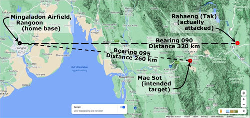
08 Jan 1942: Homebased at Mingaladon1 (Google Maps link), Rangoon’s airport, the 2nd Squadron (aka “Panda Bears”) of the Flying Tigers–American Volunteer Group (AVG) was assigned to attack Mae Sot airfield2 (Google Maps link), where Ki‑30 light bombers of the 31st Sentai, which had participated in the Christmas raids on Rangoon,3 were believed to have been located.4
A flight of four P‑40s led by Charley Mott, mistakenly attacked the airfield at Rahaeng (Google Maps link to present-day Tak5) which was about 60 km ENE of their target, Mae Sot:6‘7
Nonetheless, the Allies could have considered their attack a success with the Japanese recording four IJAAF Ki-27 fighters of the 77th Sentai along with one transport aircraft destroyed; and three more Ki-27s damaged.8 However, Japanese ground fire did down Charley Mott’s P-40 during that attack. Mott successfully bailed out, but incurred injuries on landing and was taken prisoner.
References (listed chronologically by publication date)
• Ford, 1991:9
. . . January 8, [1942]. Charlie Mott led the mission, accompanied by Robert (Moose) Moss, Gil Bright, and Percy Bartelt. Their target was Mae Sot, in the valley that marked the Thai-Burma frontier, where the Japanese were building a new airfield.10 Leaving Bright to fly top cover at 6,000 feet, Mott and the others “went down to do the business,” as he told me years later. After his first screaming pass over the aircraft on the field, Mott spotted two planes hidden in the rain forest. He lifted his wing and swung back to strafe them. Then his world fell apart: “There was a big boom up in the engine, and the thing quit cold. I was [about] thirty feet off the ground. I had quite a bit of speed, naturally, and I pulled up and started to work on the engine, shifting fuel tanks and so on. But by that time I was out of airspeed. I rolled over — oh, I was 200 or 300 feet off the ground — and I kicked out.” His parachute opened just before he hit, saving his life but leaving him with cracked ribs and a broken arm, leg, and pelvis. Japanese soldiers picked him up and took him to Raheng, where the 55th Division had set up headquarters in preparation for its invasion of Burma. His painful journey ended for the time being at Chulalongkorn University in Bangkok, which the Japanese had converted to a prison camp. . . .
• Shores, 1992 (emphasis added)11
Thursday, 8 January
. . . four 2nd AVG Squadron P-040s were despatched to strafe Mesoht airfield, where they claimed eight aircraft destroyed on the ground. The Japanese reported that four Ki 27s of the 77th Sentai were burned and three damaged, and that a transport aircraft was also destroyed in flames — but at Raheng, rather than Mesoht! The AA defences claimed two P‑40s shot down and, in fact, [only] Flt Ldr Charlie Mott’s aircraft was hit, but he successfully force-landed in a clearing near the airfield and managed to jump clear before his aircraft burst into flames. He was taken prisoner . . . .
• Umemoto, 2002:12
Entry for Charlie Mott (Umemoto, p 461) Item Japanese English translation Date 昭和17年1月8日 08 Jan 1942 Unit 2Sqn/AVG 2Sqn/AVG Casualty P-40B Curtiss P-40 Warhawk Pilot チャーリー•モット大尉 Captain Charlie Mott Location チェンマイ飛行場 Chiang Mai Airport Shooter 対空砲火 Anti-aircraft fire Details 落下傘降下•捕虜 Parachuted; POW Note that Umemoto placed the crash incorrectly in Chiang Mai, not Tak or Mae Sot.
一方、ラーヘン飛行場の対空射撃班は、P40の撃墜確実ー機、不確実ー機を報じた:実際、,ノ苯指揮 官のチャ—リー.モット機は被弾、かれは機体が炎に包まれる前に落下傘降下。そして捕虜になつた。13
[Umemoto comment]:. . . the anti-aircraft battery at Rahaeng Airfield reported the shooting down of a P-40. In fact, Flight Commander Charlie Mott’s plane was hit, and engulfed in flames. He parachuted out before his plane crashed and he was made a prisoner.
• Bergin interview with Mott (extract):14
On January 8, 1942, as Mott flew over the Japanese airfield at Mae Sot, Thailand, his Curtiss P-40 Tomahawk was hit by ground fire.
WWII History: Your P-40 has just been hit by ground fire, your engine has quit, and despite your best efforts you can’t restart it. It is time to get out of the aircraft. How did you make your exit?
Charlie Mott: Luckily, I had a lot of speed, about 350 miles per hour, and was able to zoom up to about 400 feet. I rolled over, slid back the canopy, released the safety belt, and shoved the stick forward. I was catapulted out into space. I found myself head-down and pulled the ripcord. After a terrific yank, I took one swing, and then stopped nice and gently. . . . The canopy had caught in the top branches of a giant tree. I was dangling . . . about 35 feet from the ground. . . .
. . . below me was a bush. Not a big bush, but I thought it would cushion my fall. I undid my harness and dropped down. I missed the bush and hit the ground with a thud. My right leg crumpled under me. I hit on my right flank and rolled, banging my head on the ground. My left arm broke above the wrist, a compound fracture, with the jagged end stuck in the dirt. Something was wrong in my pelvic area. I lay there, immobilized. . . . They put me on the stretcher, and off we went. Back to the airfield I had just strafed, about a mile away. . . . [after interrogation] They put me in a truck on a pile of rice straw so I would have an easy ride over the rough road. . . . I spent the night at a Japanese encampment. . . . The following morning, I was taken to the railroad station.
Crash site location
There is a conflict among sources as to where Mott was shot down: he is recorded as having been ordered by the AVG to attack the airfield at Mae Sot; however, relying on IJAAF records, Umemoto records Mott having gone down at Rahaeng (Tak).15 Tending to confirm that location, Umemoto, again relying on IJAAF logs, also records the destruction of seven IJAAF aircraft on the ground16 at Rahaeng which would approximate the eight reported by returning AVG pilots.17 Shores, et al, note the discrepancy.18
Mott’s recollection to Bergin of crashing in Mae Sot was in fact an error (as would have been the reports about the attack from returning flight members). Crucial to this conclusion is Mott’s nonchalant comment, “The following morning, I was taken to the railroad station.” In January 1942, specifically 08 January 1942, the day of his crash, there was no traversable road east from Mae Sot. The brief uneventful travel that Mott recalled from the airfield to a rail station (presumably Phitsanulok, about 226km from Mae Sot or possibly Sawankhalok, about 192km) could only have been from Rahaeng.
References about crash site:
M Sivaram, in The Road to Delhi,19 records his own escape attempt via Mae Sot [in December 1941] . . . Sivaram took a day using scheduled trains and a bus to get to Tak. But on foot with ponies carrying his luggage it took him another three and a half days to get to Mae Sot.
Sivaram’s three and a half days on foot with ponies carrying his luggage to get to Mae Sot jibes with an account nearly a month later from Burma 1942: The Japanese Invasion:20
On 28 December, an advance party of a platoon of infantry and a party of the BIA [Burma Independence Army] . . . started for Mae Sot . . . . From Raheng it was about forty miles to Mae Sot. Between these two places were two ranges of hills, two to three thousand feet high and covered with dense tropical forest, genuine jungle as the word is commonly understood. Across these hills was a narrow and steep path, impassable for vehicles, so a strong force of Japanese and Thai sappers, supported by infantry working parties, were set to work to produce a motorable track.
It being impossible at this stage to get trucks to the border, the Japanese planned to carry out the first phase of their campaign without vehicles . . . soldiers were required to carry heavy loads of food and ammunition and the bicycle company to carry their machines as well as their weapons. . . . it took four long days to reach Mae Sot . . . [arriving] in the middle of January [1942] . . . .
The main [Japanese] attack started at 0500 on 20 January [1942]. The [Gurkha] platoon in Miyawadi was surprised in the dark.
Referencing Senshi Sosho, Reynolds wrote:21
. . . the Thai assisted the Japanese 15th Army in overcoming the transportation deficiencies that posed the most formidable obstacles to the invasion of Burma. Although experts had estimated that it would take five months to turn the 120-kilometer trail from Tak to the Burmese border into a usable motor road, the Thai and Japanese armies undertook a crash program to accomplish this in 50 days. The governor of Phitsanulok province and the mayor of Sukhothai received medals from the Japanese army for their cooperation, Thai army liaison personnel assisted in various ways, and Thai students from the Bangkok Japanese Language School came to provide interpreting services. The semiofficial Japanese history of the Burma campaign described Thai cooperation as “truly devoted”.
The mix-up between airstrips at Mae Sot and Tak may have occurred because:
- While maps of much of the Far East existed at that time, they seemed not to have been commonly available: Edwin Layton recalled Pentagon personnel reacting to the attack on Pearl Harbor and the Philippines by going to the Washington headquarters of the National Geographic Society for maps.22 While Britain had mapped Burma, Malaya, and even parts of China, and France had done the same for its Indochina, all well before the war, Thailand, with its independence from foreign control, had not received that same attention.
- On the other hand, the origin of this attack, Rangoon, was the capital of British Burma, with colonial offices located there. The whole territory had been well explored by Survey of India teams; various scale maps had been published and should have been available from colonial offices there for use of the American Volunteer Group for their attack on Mae Sot. But perhaps they were not. Though in Thailand, Mae Sot was just across the Moei River from Myawaddy, which was named on Survey of India maps. The extract below from a Survey of India index map dated 1928, thirteen years before Mott’s flight, indicates that the Rangoon and “Myawadi” (Myawaddy) areas (both names circled in red) had been surveyed (with Tak (Rahaeng) circled in dark red further east). The Thai-Burmese border is traced in yellow:23

- Mott’s flight took off from Mingaladon, Rangoon’s airport. From there to Mae Sot is 260 air-km, on a heading 095, while Rahaeng (Tak) is 320km, at 090. With a cruising speed of about 500 kph, flight times were 30 min and 38 min, respectively, which could have been substantially impacted by wind. Both airfields have rivers to their west, though that at Mae Sot, the Moei, distinctly meanders while that at Tak, the Ping, is by comparison fairly straight and much broader. The air facilities themselves were generally similar, each having two runways. This table specifically compares the two:24
Transcript:
| Item | Mesawt | Tak (Raheng) |
| Type | C [Civil] | M [Military] |
| Position | N16°41 E98°31 | N16°53 E99°09 |
| Altitude | 700 | 310 |
| Location | 2 mi NW of town, on E bank of river Mey (Meoy) 160 mi from Rangoon | 2 mi E of town |
| Dimensions | 6,000′ x 2,400′, 2 runways 3,000′ x 600′ (approx) |
Formerly 2 landing strips NE/SW and E/W 2,640′ x 390′ (has been extended) |
| Surface | Very hard soil, usable even after heavy rains | Always serviceable |
| Facilities | W/T and D/F, hangar, fuel storage, British destroyed Japanese ships on ground in late January 1942 | Has accommodated Japanese bombers and fighter aircraft. |
● Equally important, IJAAF aircraft were present on both fields on this date.
An oddity in this US data is that, while issued in June 1942, it includes only mention of British destroying Japanese [air]ships on the ground at Mae Sot in late January 1942 (Shores does recount Blenheims bombing Rahaeng on 21-22 January, but without mention of any results). Further, no mention is made of the AVG having hit eight Japanese aircraft at Mae Sot on 08 January.
With regard to the wreckage of Mott’s P-40, no doubt the IJA salvaged it both for its value to intelligence and for its aluminum; and thus it’s unlikely that any identifiable wreckage remains at the crash site. From accounts by Ford and Bergin, it’s not clear where Mott’s P-40 crashed in relation to the airstrip or its heading when he bailed out (Mott only recalled that he had crashed about a mile from the airfield). To complicate matters further, as already noted, after the war the Tak airstrip was relocated about 11 km east; and the area around the former airfield site has seen considerable development since.
Afterword
After recovering from injuries from bailing out, Mott, as a POW, spent the rest of the war working on the Thai-Burma “Death Railway”. Mott summarized his activities after the war to Bergin:25
I went back to the Navy and, as promised when I joined the AVG, I got my rank back. In time I was selected for a regular commission and retired in 1963. I continued as a corporate consultant on aviation, ordnance, and guided missiles.
Mott died on 30 July 2004 in Vienna VA, USA.26
| First published on Internet | ||
| Add copy para, change title, footer | ||
| Converted to WordPress by Ally Taylor | ||
| Updated, author major errors & typos corrected | ||
Last Updated on 17 February 2026
- N16°54.5 E96°08.0[↩]
- N16°42.18 E98°32.67[↩]
- Shores, Cull, with Izawa, Blood Shambles, vol 1 (London: Grub Street, 1992), pp 241-250[↩]
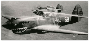
- Photo from The Flying Tigers In Defence of Rangoon[↩]
- N16°52.655 E99°8.919[↩]
- Note that the air facility at Mae Sot was reconfigured after the war, and that at Tak was moved about 11 km easterly along Thai Route 12 after the war to its present-day location.[↩]
- Extract from Google Maps, annotated by author using Microsoft Publisher.[↩]
- 梅本弘 [Umemoto, Hiroshi], ビルマ航空戦・上 [Air War in Burma, Vol 1] (Tokyo: Dai Nippon, 2002)], p 451, lines 12-18[↩]
- Ford, Dan, Flying Tigers (Washington: Smithsonian, 1991, 2007), pp 150-151.[↩]
- Correction: the field was not under construction at that time: Thailand’s Aerial Transport Company had built it in 1931-1932. For Fiscal Year ending 31 March 1940, there had been 196 flights between Mae Sot and Phitsanulok. (Edward Young, Aerial Nationalism (Washington: Smithsonian, 1995), p 100) [↩]
- Shores, Christopher and Brian Cull with Yasuho Izawa, Bloody Shambles, Vol One (London: Grub Street, 1992), p 254.[↩]
- 梅本弘 [Umemoto], ibid, line 11[↩]
- Ibid, p 50.[↩]
- Bergin, Bob, Charlie Mott: Flying Tiger Caged, Warfare History Network (offsite link). This is the most comprehensive account of Mott’s shootdown.[↩]
- Umemoto, ibid[↩]
- Ibid.[↩]
- Ford, ibid.[↩]
- Shores, et al, ibid.[↩]
- Sivaram, M, The Road to Delhi (Rutland: Tuttle, 1966), pp 55-61[↩]
- Ian Lyall Grant and Kazuo Tamayama, Burma 1942: The Japanese Invasion (Chichester: Zampi, 1999), pp 60-61, 64.[↩]
- Reynolds, EB, Thailand and Japan’s Southern Advance 1940-1945 (New York: St Martins Press, 1994), p 115.[↩]
- Layton, Adm Edwin, And I Was There (New York: Morrow, 1987), page ref needed.[↩]
- Survey of India, Index to large scale maps, No. 94 corrected to Mar 1928; reference required; my ref: \03200 Sakpinit P books\Maps\Burma with TH\00,00 094 Index–Survey of India 63k and 50k 6-23 part.jpg[↩]
- Airport Directory South East Asia (Washington: USAAF, 28 June 1942), pp 16, 18 [my ref: \03400 USFE Cmd Documentation\_Airfields List (Sak)\1942 Originals\1942 origs meld.jpg] W/T: wireless telegraph D/F: direction finder[↩]
- Bergin, ibid.[↩]
- The Washington Post, 04 August 2004.[↩]